L'Index to Chalet du Lac Blanc
Walk 6003
Country - France
Region - Haute Savoie (74) - Chamonix Valley
Author - Lou Johnson
Length - 4.0 km / 2.5 miles
Ascent - 175 metres / 578 feet
Descent - 415 metres / 1370 feet
Time - 1.75 hours
Grade - easy/mod
Click image to visit gallery of 9 images.
This short route is packed with interest. With the Aiguilles Rouges in close proximity for the full length of the walk and long distance views across the Chamonix valley to the Aiguille Verte and the Chamonix Aiguilles, this is a walk where the pace should be leisurely. There is also the added attraction of a beautifully situated lake with a very pleasant chalet serving excellent food and refreshments.
The walk starts from the upper station of the Chalet de la Flégère to L'Index chairlift, which takes you up to 2385 m. Although signed, the start of the path is indistinct. From the chairlift station go northeast and after 100 metres the path becomes more obvious and is well way-marked with paint flashes on rocks.
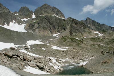
The route climbs slightly before descending quite steeply into a rocky amphitheatre where you cross a stream. This could be difficult after heavy rain. The path is always rocky underfoot although much work has been completed to make progress as easy as possible and this evident on the next section where large rocks have been moved to form a rudimentray pavement. Crossing a steep slope the path rounds a corner to reach a signed cairn that marks the entrance to the 'Réserves Naturelle des Aiguilles Rouges'.
Once in the Reserve the path climbs quite sharply for a short way before levelling out with the shores of Lac Blanc and the Chalet soon in view. In good weather you will not be alone and it is worth exploring perhaps spening some time on the shores of the upper lake, which is missed by many visitors.
Things to consider - The chalet refuge is only open mid-June until the end of September. Good footwear is essential on this route as it is rocky underfoot. Early and late season snow may cover sections of the path so walking poles are an advantage.
Suggested Maps
 - Carte de Randonnées "Sheet A1 - Pays due Mont-Blanc" published by Rando Editions. 1:50000 scale - Sheet A1
- Map of Mountain Footpaths in Summer - 1:40000 - Published by the Office de Tourisme
- IGN Carte de Randonnée - Chamonix - Massif de Mont Blanc - 1:25000 Sheet 3630OT
Stay Safe
Do enjoy yourself when out walking and choose a route that is within your capabilities especially with regard to navigation.
Do turn back if the weather deteriorates especially in winter or when visibility is poor.
Do wear the right clothing for the anticipated weather conditions. If the weather is likely to change for the worse make sure you have enough extra clothing in your pack.
Do tell someone where you are planning to walk especially in areas that see few other walkers.
Do take maps and other navigational aids. Do not rely on mobile devices in areas where reception is poor. Take spare batteries especially in cold weather.
Do check the weather forecast before leaving. The Met Office has a number of forecasts for walkers that identify specific weather risks.
Please Note - These walks have been published for use by site visitors on the understanding that Walking Britain is not held responsible for the safety or well being of those following the routes as described. It is worth reiterating the point that you should embark on a walk with the correct maps preferably at 1:25000 scale. This will enable any difficulties with route finding to be assessed and corrective action taken if necessary.