Col de Balme to Le Tour
Walk 6006
Country - France
Region - Haute Savoie (74) - Chamonix Valley
Author - Lou Johnson
Length - 6.0 km / 3.8 miles
Ascent - 370 metres / 1221 feet
Descent - 670 metres / 2211 feet
Time - 2.75 hours
Grade - easy/mod
Click image to visit gallery of 3 images.
This is an good walk with some uphill effort required. The views along the valley towards Chamonix are first rate and you have the bonus of seeing some of Switzerland's higher peaks.
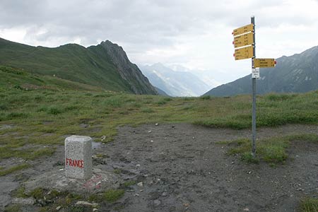
Take the Télécabine from Le Tour to Chalet de Charamillon and continue on the connecting Télésiege des Autannes to its mountain terminus. After alighting take the clear track north to the Col De Balme with its stone-built refuge. Note the boundary stones that mark the frontier between Switzerland and France. From the refuge take the clear path northwest to the summit of the Tête de Balme (2321 m.). From here the grand views in all directions most notably towards Mont Blanc and the Aiguilles Rouges.
Return to the Refuge at Cole de Balme and take the clear path that descends southwest to Chalet de Charamillon. You are now on the Tour du Mont Blanc trail. Ahead there is a grand panorama of the Arve Valley and its surrounding mountains. To continue the descent take the path to Le Tour. This drops, steeply in places, with the Télécabine on your left. On arrival in Le Tour do allow time for some exploration as this is a pretty village with many interesting buildings.
Things to consider - Despite the low-level nature of this walk, do chose a day with good visibility as the views from the Tête de Balme are excellent. In poor weather there is very little natural shelter.
Suggested Maps
 - Carte de Randonnées "Sheet A1 - Pays due Mont-Blanc" published by Rando Editions. 1:50000 scale - Sheet A1
- Map of Mountain Footpaths in Summer - 1:40000 - Published by the Office de Tourisme
- IGN Carte de Randonnée - Chamonix - Massif de Mont Blanc - 1:25000 Sheet 3630OT
Stay Safe
Do enjoy yourself when out walking and choose a route that is within your capabilities especially with regard to navigation.
Do turn back if the weather deteriorates especially in winter or when visibility is poor.
Do wear the right clothing for the anticipated weather conditions. If the weather is likely to change for the worse make sure you have enough extra clothing in your pack.
Do tell someone where you are planning to walk especially in areas that see few other walkers.
Do take maps and other navigational aids. Do not rely on mobile devices in areas where reception is poor. Take spare batteries especially in cold weather.
Do check the weather forecast before leaving. The Met Office has a number of forecasts for walkers that identify specific weather risks.
Please Note - These walks have been published for use by site visitors on the understanding that Walking Britain is not held responsible for the safety or well being of those following the routes as described. It is worth reiterating the point that you should embark on a walk with the correct maps preferably at 1:25000 scale. This will enable any difficulties with route finding to be assessed and corrective action taken if necessary.