Planpraz to Le Brévent
Walk 6009
Country - France
Region - Haute Savoie (74) - Chamonix Valley
Author - Lou Johnson
Length - 3.5 km / 2.2 miles
Ascent - 580 metres / 1914 feet
Descent - 55 metres / 182 feet
Time - 1.50 hours
Grade - easy/mod
Click image to visit gallery of 9 images.
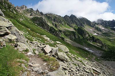
This walk takes you into some rugged country offering fine views over many of the peaks in the Chamonix area. In addition views north to very different terrain are also enjoyed. The route includes the ascent of one short fixed ladder. This should not provide any problems for the majority of fit walkers.
Take the Télécabine from Chamonix to Planpraz. Exit the cablecar station and walk northwest along a track keeping the ski-lift on your right. After a short way you reach a junction of paths. Take the right fork to contour across the mountainside.
This path leads without problem to a col with a large cairn. This is the Col du Brévent from where wide ranging views to the north appear. At the col take the left hand path (i.e. do not descend into the valley). This is the TMB with the path soon descending into a rocky valley. At all times the way ahead is clear. The path starts to climb and after a short way a fixed ladder takes you up a rock wall. Once this has been cleared the path continues to reach a broad track. Turn right and after a short way you reach the top station of the cablecar to Le Brévent where refreshments are usually available. Superb panoramic views include Chamonix and the mountains beyond (including Mont Blanc). the view west to Les Houches and northwards to the Desert de Plate and the Rocehrs de Fiz.
To continue - This route links to Walk 6010.
Suggested Maps
 - Carte de Randonnées "Sheet A1 - Pays due Mont-Blanc" published by Rando Editions. 1:50000 scale - Sheet A1
- Map of Mountain Footpaths in Summer - 1:40000 - Published by the Office de Tourisme
- IGN Carte de Randonnée - Chamonix - Massif de Mont Blanc - 1:25000 Sheet 3630OT
- IGN Carte de Randonnée - Samoëns - Haut Giffre - 1:25000 Sheet 3530ET
Stay Safe
Do enjoy yourself when out walking and choose a route that is within your capabilities especially with regard to navigation.
Do turn back if the weather deteriorates especially in winter or when visibility is poor.
Do wear the right clothing for the anticipated weather conditions. If the weather is likely to change for the worse make sure you have enough extra clothing in your pack.
Do tell someone where you are planning to walk especially in areas that see few other walkers.
Do take maps and other navigational aids. Do not rely on mobile devices in areas where reception is poor. Take spare batteries especially in cold weather.
Do check the weather forecast before leaving. The Met Office has a number of forecasts for walkers that identify specific weather risks.
Please Note - These walks have been published for use by site visitors on the understanding that Walking Britain is not held responsible for the safety or well being of those following the routes as described. It is worth reiterating the point that you should embark on a walk with the correct maps preferably at 1:25000 scale. This will enable any difficulties with route finding to be assessed and corrective action taken if necessary.