Ailefroide - Refuge du Sélé, Ecrins
Walk 6015
Country - France
Region - Haute Alpes (05) - Vallee de la Vallouise - Ecrins NP
Author - Lou Johnson
Length - 14.0 km / 8.8 miles
Ascent - 1000 metres / 3300 feet
Descent - 1000 metres / 3300 feet
Time - 6.00 hours
Grade - hard
Click image to visit gallery of 6 images.
This walk contains some sections where a head for heights and some scrambling skills are essential. However the majority of the walk can be enjoyed without the need for serious scrambling although this will mean stopping short of the Refuge. Therefore it is important to take all your food and drinks with you.
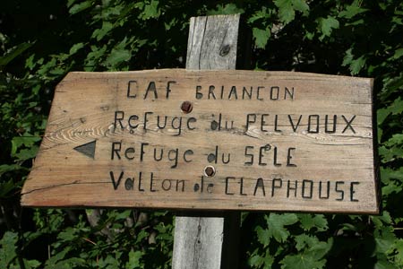
For the purposes of this description the walks starts from the small chapel on the main street of the village. From here walk north along the road to a junction. Turn left. This will lead you past the edge of the large camping area on your left to reach a car park (an alternative start if you have transport). Go through the car park and follow the clear path signed to the "Refuge du Sele, Refuge du Pelvoux and Claphouse".
The going is fairly level with the path following the river upstream to reach a path junction in just over 15 minutes. Ignore the path going left across the bridge and continue upstream. The path is within sight or sound of the river for virtually the whole route. The path climbs steadily using ziz-zags and loops where necessary to reach another junction where the path to Refuge du Pelvoux goes right.
Continue straight ahead. You will have probably spotted the Refuge du Sélé by now perched atop a crag on the right hand side of the valley. The path reaches a fairly level section with a step in the valley ahead. The river cascades over this step with a rock wall to its right. This is where the path suddenly becomes interesting and rather more challenging.
Just before reaching the step in the valley floor, the path negotaites a boulder field. Exiting this you reach the first of a number of sections with cables to assist your ascent and subsequent descent. The path goes left for a short distance before turning and heading left up and across the rock wall. In a few places there is a degree of exposure with a a couple of short sections that are awkward rather than intimidating. Eventually the problems are overcome and the path delivers you to the Refuge where food and drinks can be obtained.
The return to Ailefroide follows the same route as used for the outward walk.
Suggested Maps
 - IGN Carte de Randonnée - Meije Pelvoux - Parc National des Ecrins - 1:25000 Sheet 3436ET
Stay Safe
Do enjoy yourself when out walking and choose a route that is within your capabilities especially with regard to navigation.
Do turn back if the weather deteriorates especially in winter or when visibility is poor.
Do wear the right clothing for the anticipated weather conditions. If the weather is likely to change for the worse make sure you have enough extra clothing in your pack.
Do tell someone where you are planning to walk especially in areas that see few other walkers.
Do take maps and other navigational aids. Do not rely on mobile devices in areas where reception is poor. Take spare batteries especially in cold weather.
Do check the weather forecast before leaving. The Met Office has a number of forecasts for walkers that identify specific weather risks.
Please Note - These walks have been published for use by site visitors on the understanding that Walking Britain is not held responsible for the safety or well being of those following the routes as described. It is worth reiterating the point that you should embark on a walk with the correct maps preferably at 1:25000 scale. This will enable any difficulties with route finding to be assessed and corrective action taken if necessary.