Ailefroide - Refuge du Pelvoux, Ecrins
Walk 6016
Country - France
Region - Haute Alpes (05) - Vallee de la Vallouise - Ecrins NP
Author - Lou Johnson
Length - 14.0 km / 8.8 miles
Ascent - 1200 metres / 3960 feet
Descent - 1200 metres / 3960 feet
Time - 7.00 hours
Grade - mod/hard
Click image to visit gallery image.
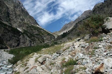
This walk contains a section of concerted uphill walking to reach the Refuge. The path climbs in a series of loops offering wonderful views into the valley below with mountains as a backdrop.
This walk starts from the small chapel on the main street of the village of Ailefroide. From here walk north along the road to a junction. Turn left. This will lead you past the edge of the large camping area on your left to reach a car park (an alternative start if you have transport). Go through the car park and follow the clear path signed to the "Refuge du, Refuge du Pelvoux and Claphouse".
The going is fairly level with the path following the river upstream to reach a path junction in just over 15 minutes. Ignore the path going left across the bridge and continue upstream. The path is within sight or sound of the river for virtually the whole of this valley section. The path climbs steadily using ziz-zags and loops where necessary to reach another junction where the path to Refuge du Sele goes straight on.
Take the right hand path and immediately start to climb. You have about two hours of almost solid uphill walking to reach the Refuge. The environment becomes progressively wilder as height is gained. The Refuge is not seen until the last moment and occupies a stunning position with a wide ranging panorama especially to the south.
The return to Ailefroide follows the same route as used for the outward walk.
Suggested Maps
 - IGN Carte de Randonnée - Meije Pelvoux - Parc National des Ecrins - 1:25000 Sheet 3436ET
Stay Safe
Do enjoy yourself when out walking and choose a route that is within your capabilities especially with regard to navigation.
Do turn back if the weather deteriorates especially in winter or when visibility is poor.
Do wear the right clothing for the anticipated weather conditions. If the weather is likely to change for the worse make sure you have enough extra clothing in your pack.
Do tell someone where you are planning to walk especially in areas that see few other walkers.
Do take maps and other navigational aids. Do not rely on mobile devices in areas where reception is poor. Take spare batteries especially in cold weather.
Do check the weather forecast before leaving. The Met Office has a number of forecasts for walkers that identify specific weather risks.
Please Note - These walks have been published for use by site visitors on the understanding that Walking Britain is not held responsible for the safety or well being of those following the routes as described. It is worth reiterating the point that you should embark on a walk with the correct maps preferably at 1:25000 scale. This will enable any difficulties with route finding to be assessed and corrective action taken if necessary.