Refuge Albert Premier & Col De Balme
Walk 6017
Country - France
Region - Haute Savoie (74) - Chamonix Valley
Author - Lou Johnson
Length - 10.0 km / 6.3 miles
Ascent - 600 metres / 1980 feet
Descent - 600 metres / 1980 feet
Grade - moderate
Click image to visit gallery of 12 images.
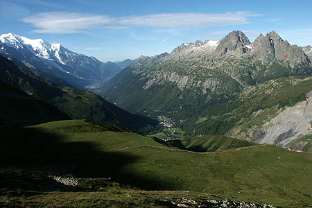
The Refuge Albert Premier makes a wonderful objective for a day in the mountains. The route is an out and back walk offering extensive views of the Chamonix Valley, the Glacier du Tour and its surrounding mountains. Also included in the scenic delights are Mont Blanc, Mont Buet, Aiguilles de Chardonnet and the Aiguille Rouges.
Take the Télécabine from Le Tour to Chalet de Charamillon and continue on the connecting Télésiege des Autannes to its mountain terminus. After alighting take the clear track south signed to the Refuge. The scenery is immediately impressive with Mont Blanc rising above the Chamonix Valley. The path is clear and progress fast with little ascent until you reach pretty Lac de Charamillon on your right. Continuing south the path starts to climb.
Turning east you get the first of what will be a continuous vista of rock and ice. Below on your right is the snout of the Glacier du Tour. Alongside on the moraine you can see the path coming up from the village of Le Tour. You are now entering a rocky landscape with the path twisting a turning to reach the moraine. Climbing onto the moraine, the way ahead becomes steeper with the Refuge in clear view on the skyline. Even in late June early July the final section of the path was covered in snow, although the passage of many boots had created a series of steps. Reaching the Refuge you can relax and enjoy the view.
The return route follows the outward walk. However it is worth continuing along the main track to Col de Balme and its refuge. From here you get good views east into Switzerland with Franco-Swiss border marked by a granite stone. From the Col you might wish to climb to the Croix de Fer (See Walking Switzerland for details). After exploring the Col de Balme return along the track to the top station of the Télésiege and start the descent back to le Tour.
Suggested Maps
 - Carte de Randonnées "Sheet A1 - Pays due Mont-Blanc" published by Rando Editions. 1:50000 scale - Sheet A1
- Map of Mountain Footpaths in Summer - 1:40000 - Published by the Office de Tourisme
- IGN Carte de Randonnée - Chamonix - Massif de Mont Blanc - 1:25000 Sheet 3630OT
Stay Safe
Do enjoy yourself when out walking and choose a route that is within your capabilities especially with regard to navigation.
Do turn back if the weather deteriorates especially in winter or when visibility is poor.
Do wear the right clothing for the anticipated weather conditions. If the weather is likely to change for the worse make sure you have enough extra clothing in your pack.
Do tell someone where you are planning to walk especially in areas that see few other walkers.
Do take maps and other navigational aids. Do not rely on mobile devices in areas where reception is poor. Take spare batteries especially in cold weather.
Do check the weather forecast before leaving. The Met Office has a number of forecasts for walkers that identify specific weather risks.
Please Note - These walks have been published for use by site visitors on the understanding that Walking Britain is not held responsible for the safety or well being of those following the routes as described. It is worth reiterating the point that you should embark on a walk with the correct maps preferably at 1:25000 scale. This will enable any difficulties with route finding to be assessed and corrective action taken if necessary.