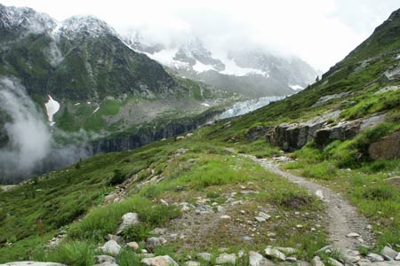
The Argentière Glacier from la Croix de Lognan
Walk 6018
Country - France
Region - Haute Savoie (74) - Chamonix Valley
Author - Lou Johnson
Length - 6.0 km / 3.8 miles
Ascent - 370 metres / 1221 feet
Descent - 370 metres / 1221 feet
Time - 2.50 hours
Grade - easy/mod
Click image to visit gallery of 9 images.
This short walk offers excellent views over the Argentière Glacier and takes you very close to the ice. Perhaps after this walk you might have a different view of glaciers. Often seen as white and pristine, the close encounters with the ice will emphasise the way the ice is eroding vast quantities of material from the landscape over which it passes. Glaciers are in reality dirty and unromantic.
Take the Grands Montets cablecar to the middle station - la Croix de Lognan. If you are intending to go to the summit later, it is cheaper to purchase a return ticket to the summit and break your journey at the middle station to do this walk. Exit the cablecar station into an area spoiled by a large number of ski-lifts and other skiing infrastructure. Just above the station is a signpost - take the path to the viewpoint of the Argentière Glacier.
The broad path leads across the mountainside gaining height easily. The views across and into the Chamonix Valley are good. You pass the Chalet Militaire de Lognan, below on your right, and from here the path continues to reach the viewpoint in about 20 minutes. The viewpoint is close to part of a hydro-electric gallery and you are able to face to face with ice and its load of rock debris. The ice is jumbled into cliffs, crevasses and seracs as it 'falls' into the valley below.
You may continue higher by taking take the path just to the left of the gallery. This climbs a further 160 metres to offer a wider view of the glacier. Opposite are the crags of the Aiguille de Chardonnet and behind is the Glacier des Rognans backed by the Aiguille des Grands Montets. Overall a very impressive scene of rock and ice. The return route follows the outward path although you might wish to visit the Chalet Militaire for some refreshments especially if the weather is fine. If continuing to the summit station of the cablecar, you can look down towards the viewpoint you have just visited.
Suggested Maps
 - Carte de Randonnées "Sheet A1 - Pays due Mont-Blanc" published by Rando Editions. 1:50000 scale - Sheet A1
- Map of Mountain Footpaths in Summer - 1:40000 - Published by the Office de Tourisme
- IGN Carte de Randonnée - Chamonix - Massif de Mont Blanc - 1:25000 Sheet 3630OT
Stay Safe
Do enjoy yourself when out walking and choose a route that is within your capabilities especially with regard to navigation.
Do turn back if the weather deteriorates especially in winter or when visibility is poor.
Do wear the right clothing for the anticipated weather conditions. If the weather is likely to change for the worse make sure you have enough extra clothing in your pack.
Do tell someone where you are planning to walk especially in areas that see few other walkers.
Do take maps and other navigational aids. Do not rely on mobile devices in areas where reception is poor. Take spare batteries especially in cold weather.
Do check the weather forecast before leaving. The Met Office has a number of forecasts for walkers that identify specific weather risks.
Please Note - These walks have been published for use by site visitors on the understanding that Walking Britain is not held responsible for the safety or well being of those following the routes as described. It is worth reiterating the point that you should embark on a walk with the correct maps preferably at 1:25000 scale. This will enable any difficulties with route finding to be assessed and corrective action taken if necessary.