Lac Cornu from Planpraz
Walk 6021
Country - France
Region - Haute Savoie (74) - Chamonix Valley
Author - Lou Johnson
Ascent - 415 metres / 1370 feet
Descent - 415 metres / 1370 feet
Time - 3.50 hours
Grade - easy/mod
Click image to visit gallery of 9 images.
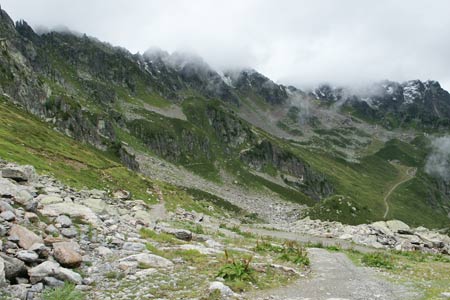
This excellent walk provides excellent views across the Chamonix Valley to the Aiguille du Mid, Aiguille Verte and many other mountain peaks. The route crosses the main ridge of the Aiguille Rouge to the pleasantly located Lac Cornu. In early season expect snow on some sections of the route. Even in late June expect poor weather as the images accompanying this route show.
The start is the tope station of the Telecabine from Chamonix to Planpraz. Exit the cablecar station and walk northwest along a track keeping the ski-lift on your right. After a short way you reach a junction of paths. Take the right fork to contour across the mountainside. This is the TMB (Tour Mont Blanc) signed for Chalet de la Flégère. This path soon splits - take the left fork for the Col du Lac Cornu.
The route gradually climbs across the mountainside offering excellent views (in good weather) especially across the valley. Progress is fast on a well graded path. Nearing the Col du Lac Cornu there are a few zigzags that lead up to the large cairn in the col.
Take the descending path on the other side and bear left at the first junction. By this time you should have had your first sight of the Lac Cornu. All that remains is the descent to the lake where you can usually enjoy the solitude amidst the mountains. The return route follows the path used for the outward journey. If you have time you can also visit the Lacs Noirs. These are reached by turning left at the junction just before the col and descending to the lakes. This adds about 120 metres of ascent and an hour of walking time.
Suggested Maps
 - Carte de Randonnées "Sheet A1 - Pays due Mont-Blanc" published by Rando Editions. 1:50000 scale - Sheet A1
- Map of Mountain Footpaths in Summer - 1:40000 - Published by the Office de Tourisme
- IGN Carte de Randonnée - Chamonix - Massif de Mont Blanc - 1:25000 Sheet 3630OT
- IGN Carte de Randonnée - Samoëns - Haut Giffre - 1:25000 Sheet 3530ET
Stay Safe
Do enjoy yourself when out walking and choose a route that is within your capabilities especially with regard to navigation.
Do turn back if the weather deteriorates especially in winter or when visibility is poor.
Do wear the right clothing for the anticipated weather conditions. If the weather is likely to change for the worse make sure you have enough extra clothing in your pack.
Do tell someone where you are planning to walk especially in areas that see few other walkers.
Do take maps and other navigational aids. Do not rely on mobile devices in areas where reception is poor. Take spare batteries especially in cold weather.
Do check the weather forecast before leaving. The Met Office has a number of forecasts for walkers that identify specific weather risks.
Please Note - These walks have been published for use by site visitors on the understanding that Walking Britain is not held responsible for the safety or well being of those following the routes as described. It is worth reiterating the point that you should embark on a walk with the correct maps preferably at 1:25000 scale. This will enable any difficulties with route finding to be assessed and corrective action taken if necessary.