Lac Blanc to Chalet de la Flégère
Walk 6023
Country - France
Region - Haute Savoie (74) - Chamonix Valley
Author - Lou Johnson
Length - 2.5 km / 1.6 miles
Ascent - 575 metres / 1898 feet
Time - 1.50 hours
Grade - easy/mod
Click image to visit gallery of 9 images.
This straightforward descent offers incredible views across the Chamonix Valley to Aiguille des Grands Montets, Aiguille Verte and Les Drus amongst many other high mountain peaks. For part of the way the route lies within the Reserve Naturelle des Auguilles Rouges, which protects the mountain fauna and flora and also restricts the construction of skiing infrastructure.
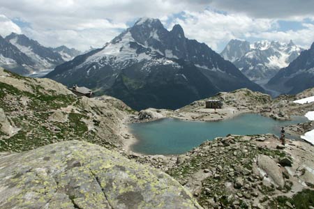
Lac Blanc. Actually two lakes, lie within an impressive mountain amphitheatre with an excellent refuge occupying a grandstand position overlooking the lower lake. Behind the lakes the Auiguilles Rouges rise impressively making it easy to see why Lac Blanc is so popular.
From Lac Blanc descend on the main path to la Flégère. The descends steadily into the valley past a small lake on the right of the path. Losing altitude less quickly the route contours across the mountainside to reach the larger Lac de la Flégère also on your right. Descending more steeply, the path begins to zigzag for the final section down to Chalet de la Flégère.
Notes - this walk connects with walk 6003 making a useful half day route where the emphasis is on downhill walking. Alternatively this walk may be completed as an out and back route from la Flégère using the cablecar from les Praz.
Suggested Maps
 - Carte de Randonnées "Sheet A1 - Pays due Mont-Blanc" published by Rando Editions. 1:50000 scale - Sheet A1
- Map of Mountain Footpaths in Summer - 1:40000 - Published by the Office de Tourisme
- IGN Carte de Randonnée - Chamonix - Massif de Mont Blanc - 1:25000 Sheet 3630OT
Stay Safe
Do enjoy yourself when out walking and choose a route that is within your capabilities especially with regard to navigation.
Do turn back if the weather deteriorates especially in winter or when visibility is poor.
Do wear the right clothing for the anticipated weather conditions. If the weather is likely to change for the worse make sure you have enough extra clothing in your pack.
Do tell someone where you are planning to walk especially in areas that see few other walkers.
Do take maps and other navigational aids. Do not rely on mobile devices in areas where reception is poor. Take spare batteries especially in cold weather.
Do check the weather forecast before leaving. The Met Office has a number of forecasts for walkers that identify specific weather risks.
Please Note - These walks have been published for use by site visitors on the understanding that Walking Britain is not held responsible for the safety or well being of those following the routes as described. It is worth reiterating the point that you should embark on a walk with the correct maps preferably at 1:25000 scale. This will enable any difficulties with route finding to be assessed and corrective action taken if necessary.