Lac du Puy Vachier & Refuge Evariste Chancel
Walk 6040
Country - France
Region - Haute Alpes (05) - La Grave & La Meije - Ecrins NP
Author - Lou Johnson
Length - 5.0 km / 3.1 miles
Ascent - 210 metres / 693 feet
Descent - 210 metres / 693 feet
Time - 2.50 hours
Grade - easy/mod
Click image to visit gallery of 12 images.
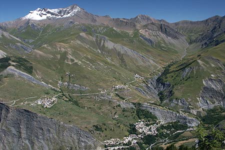
This short walk visits the Refuge Evariste Chancel passing the beautifully located Lac du Puy Vachier on the way. It also offers the chance to continue a short way the Belvedere above the Refuge, which offers a spectacular view into the Romanche Valley far below.
Start & End - Middle station of the Télépherique des glaciers de la Meije, which has its valley station in La Grave. Ample parking is available adjacent to the bottom station.
From the middle station of the Télépherique, descend to a path junction just under the cableway. Turn left and follow the clear path. You are on the northern slopes of La Meije and terrain is quite barren and very rough. To your right are spectacular views across the Romanche Valley to Mont Thabor and in the distance Mont Blanc. At first the path descends before undulating across the mountainside. At the times the route of path is not too obvious but the usual flashes of red and white paint make navigation an easy task.
Reaching a path junction, bear left and start to climb up to the Lac du Puy Vachier. This lake is wonderfully located with bare rock providing a dramatic backdrop. From the lake you can see the next objective, the Refuge Evariste Chancel, which is perched about 30 minutes walking time above the lake. Refreshments are available in season although it might be worth continuing past the refuge to the Belvedere before taking a break.
The onward path is signed from the refuge and there are a couple of sections where care is needed with a significant drop off the path to your right. Signs suggest that caution is necessary! Eventually the climbing path leads to a small viewpoint surrounded by a low stone wall. This offers one of the greatest views in the area with a bird's eye view of the Romanche Valley far below.
Having taken in the view, return by the same path back to the Gare de Pyrou d'Amont. You may wish to continue to the top station of the Télépherique, where you can have a closer encounter with the rock, snow and ice of La Meije. However after having completed this walk you will have enjoyed some excellent views of La Meije, especially from the Gare de Pyrou d'Amont.
Suggested Maps
 - IGN Carte de Randonnée - Meije Pelvoux - Parc National des Ecrins - 1:25000 Sheet 3436ET
Stay Safe
Do enjoy yourself when out walking and choose a route that is within your capabilities especially with regard to navigation.
Do turn back if the weather deteriorates especially in winter or when visibility is poor.
Do wear the right clothing for the anticipated weather conditions. If the weather is likely to change for the worse make sure you have enough extra clothing in your pack.
Do tell someone where you are planning to walk especially in areas that see few other walkers.
Do take maps and other navigational aids. Do not rely on mobile devices in areas where reception is poor. Take spare batteries especially in cold weather.
Do check the weather forecast before leaving. The Met Office has a number of forecasts for walkers that identify specific weather risks.
Please Note - These walks have been published for use by site visitors on the understanding that Walking Britain is not held responsible for the safety or well being of those following the routes as described. It is worth reiterating the point that you should embark on a walk with the correct maps preferably at 1:25000 scale. This will enable any difficulties with route finding to be assessed and corrective action taken if necessary.