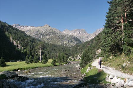
Refuge Wallon & Lac du Pourtet from Pont d' Espagne, near Cauterets
Walk 6048
Country - France
Region - Haute Pyrenees (65)
Author - Lou Johnson
Length - 17.5 km / 10.9 miles
Ascent - 1000 metres / 3300 feet
Descent - 1000 metres / 3300 feet
Grade - hard
Click image to visit gallery of 12 images.
This route is one of the walking highlights in the Cauterets area and visits the beautiful Marcadau Valley to the south of the town. It is not an easy walk and ideally should be completed in fine weather as the views are outstanding. Generally the paths are well marked and easy to follow although there are a couple of points where you need some route finding skills to avoid going astray.
To reach the start, take the D920 from Cauterets to Pont d'Espagne and park at the end of the road in the large car park. From here follow the track up the valley to the historic Pont d'Espagne. You might be tempted to take the télésiege from the car park but this provides no advantage over walking. At Pont d'Espagne bear right and continue up the Marcadau Valley. You stay on this track for some 3 km keeping the river on your right to reach Pont du Cayan.
Do not cross the river at the Pont du Cayan but bear left along the main track climbing through forest. The path descends again to reach Pont d'Estalounque after a further kilometre. Cross the river here and continue upstream now with the river to your left. The path continues a gentle ascent climbing over rocky bluffs where a riverside path is not possible due to the rocky terrain. After just over another 2 km you reach a beautiful green pasture surrounded by mountains. Soon after, you will see the Refuge Wallon a little above you to the right.
Continuing past the Refuge, the path starts to climb through small shrubs and trees. Shortly after entering open pasture you reach a junction of paths (2053m). Turn right here and continue to climb to reach Lac Nere (2309m). The path skirts the eastern shore and continues to climb to a small col from where, after a short, Lac du Pourtet is reached. The path skirts the eastern shore and roughly half way along the lake you can see the onward path far below you linking a string of small lakes. After the effort of reaching Lac du Pourtet it is worth taking a break. The scenery is stunning and you still have some work to do.
To continue drop steeply on the descent path and continue past the lakes, skirting all of them on their northern sides. After the second of the two Lacs de l'Embarrat the path turns north in a large loop. Fork right at the junction of paths and start the long descent into the valley. The descent is helped by a series of zigzags but is still seems a long way down and you arrive at the Pont du Cayan. You have two choices. You can cross the river and continue back down the track used on the outward route or for a bit of variety remain on the west side of the river and continue along the track on that side. The latter option does have the advantage that you Refuge du Clot where refreshments are usually available. Just after the Refuge cross to the other side of the river and continue down the track back to the start.
Suggested Maps
 - IGN Carte de Randonnée - Vignemalle - Ossau, Arrens, Cauterets - 1:25000 Sheet 1647OT
Stay Safe
Do enjoy yourself when out walking and choose a route that is within your capabilities especially with regard to navigation.
Do turn back if the weather deteriorates especially in winter or when visibility is poor.
Do wear the right clothing for the anticipated weather conditions. If the weather is likely to change for the worse make sure you have enough extra clothing in your pack.
Do tell someone where you are planning to walk especially in areas that see few other walkers.
Do take maps and other navigational aids. Do not rely on mobile devices in areas where reception is poor. Take spare batteries especially in cold weather.
Do check the weather forecast before leaving. The Met Office has a number of forecasts for walkers that identify specific weather risks.
Please Note - These walks have been published for use by site visitors on the understanding that Walking Britain is not held responsible for the safety or well being of those following the routes as described. It is worth reiterating the point that you should embark on a walk with the correct maps preferably at 1:25000 scale. This will enable any difficulties with route finding to be assessed and corrective action taken if necessary.