Refuge Wallon from Pont d'Espagne, near Cauterets
Walk 6050
Country - France
Region - Haute Pyrenees (65)
Author - Lou Johnson
Length - 14.0 km / 8.8 miles
Ascent - 426 metres / 1406 feet
Descent - 426 metres / 1406 feet
Grade - moderate
Click image to visit gallery of 6 images.
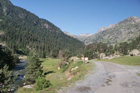
The Vallée du Marcadau is located to the south of the spa town of Cauterets. This route is follows the valley from Pont d'Espagne to the large Refuge Wallon with its outstanding position in the Pyrenees. The paths are easy to follow and it is worth choosing a fine day to enjoy the wonderful scenery.
To reach the start, take the D920 from Cauterets to Pont d'Espagne and park at the end of the road in the large car park. From here follow the track up the valley to the historic Pont d'Espagne. You might be tempted to take the télésiege from the car park but this provides no advantage over walking. At Pont d'Espagne bear right and continue up the Marcadau Valley. You stay on this track for some 3 km keeping the river on your right to reach Pont du Cayan.
Do not cross the river at the Pont du Cayan but bear left along the main track climbing through forest. The path descends again to reach Pont d'Estalounque after a further kilometre. Cross the river here and continue upstream now with the river to your left. The path continues a gentle ascent climbing over rocky bluffs where a riverside path is not possible due to the rocky terrain. After just over another 2 km you reach a beautiful green pasture surrounded by mountains. Soon after, you will see the Refuge Wallon a little above you to the right.
The return follows a similar route. Retrace your steps down the valley crossing the Pont d'Estalounque and continuing as far as the next bridge, Pont du Cayan. Cross the river here and continue down the valley now with the river on your right. The path/track is easy to follow and leads you past the Refuge du Clot where refreshments are available in season. From here cross the river and continue back to the car park.
Suggested Maps
 - IGN Carte de Randonnée - Vignemalle - Ossau, Arrens, Cauterets - 1:25000 Sheet 1647OT
Stay Safe
Do enjoy yourself when out walking and choose a route that is within your capabilities especially with regard to navigation.
Do turn back if the weather deteriorates especially in winter or when visibility is poor.
Do wear the right clothing for the anticipated weather conditions. If the weather is likely to change for the worse make sure you have enough extra clothing in your pack.
Do tell someone where you are planning to walk especially in areas that see few other walkers.
Do take maps and other navigational aids. Do not rely on mobile devices in areas where reception is poor. Take spare batteries especially in cold weather.
Do check the weather forecast before leaving. The Met Office has a number of forecasts for walkers that identify specific weather risks.
Please Note - These walks have been published for use by site visitors on the understanding that Walking Britain is not held responsible for the safety or well being of those following the routes as described. It is worth reiterating the point that you should embark on a walk with the correct maps preferably at 1:25000 scale. This will enable any difficulties with route finding to be assessed and corrective action taken if necessary.