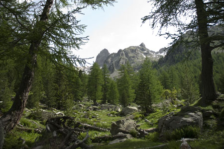
Lac de Trécolpas and the Refuge de Cougourde
Walk 6056
Country - France
Region - Alpes-Maritimes (06) - Mercantour NP & Côte d'Azur
Author - Lou Johnson
Ascent - 510 metres / 1683 feet
Descent - 510 metres / 1683 feet
Time - 4.50 hours
Grade - moderate
Click image to visit gallery of 12 images.
This walk lies almost totally within the boundaries of the Mercantour National Park and visits a beautiful lake with a picturesque small island and a mountain refuge situated in a magnificent cirque of mountains and high crags. The start of the walk is just over an hours drive from Nice. From St-Martin-Vesubie continue on the D89 up valley towards the Lac du Boreon. Continue past the lake to reach a picnic and parking area (sign no.419) at what appears to be the end of the road. The road in fact doubles back and continues to climb to reach a further parking area adjacent to sign no.420. This is the start of the walk. The route is suitable for walking between June and November although early season may see lying snow on some parts of the route.
After parking set off through the woodland on a clear track. This soon narrows to a path, which has couple of minor paths running parallel in places. At sign no.421 continue ahead to cross the boundary into the National Park. After passing Chalet Vidron (sign no.422), the path starts to climb more steeply before levelling off to cross the river on a wooden footbridge to reach sign no.423 where you bear right to follow the river upstream joining GR52.
The woodland starts to open as you climb gently into the valley. Keep straight ahead at sign no. 424 to reach another path junction at sign no.425. Turn right here remaining on GR52, cross the river and begin to climb more steeply again. Height is soon gained on a well engineered path to reach sign no.427. Bear right here and start the final ascent up to Lac de Trecolpas which will be reached in about 10 minutes. Note that in the early season there may be an extensive snow field to be crossed on this section. Reaching the lake provides a perfect place for a rest or lunch. It is a wonderful location and worth spending some time exploring.
To continue return downhill to sign no.427 and bear right. This path contours across the mountainside towards the Refuge Cougourde. The path initially crosses some scree where route finding is problematic despite a number of cairns. Once across the scree the path becomes easier to follow and it undulates across the mountainside. There are a couple of stream that need to be crossed and these might be difficult after heavy rain. After about 20 minutes the Refuge comes into sight.
The Refuge Cougourde occupies an elevated position facing south and overlooking the valley. Dominating the scene is Cougourde (2921m) with its impressive rock faces attracting many climbers. In season the refuge provides a good selection of drinks, meals and also offers accommodation.
From the Refuge cross the stream and begin the descent into the valley. The path is generally in excellent condition and you are soon back at sign no.425 (passed earlier in the walk). All that remains is to retrace your steps back to the start remembering to cross the river immediately after passing sign no. 423.
Suggested Maps
 - IGN Carte de Randonnée - Vallée de la Vésubie Parc National du Mercantour - 1:25000 Sheet 3741OT
Stay Safe
Do enjoy yourself when out walking and choose a route that is within your capabilities especially with regard to navigation.
Do turn back if the weather deteriorates especially in winter or when visibility is poor.
Do wear the right clothing for the anticipated weather conditions. If the weather is likely to change for the worse make sure you have enough extra clothing in your pack.
Do tell someone where you are planning to walk especially in areas that see few other walkers.
Do take maps and other navigational aids. Do not rely on mobile devices in areas where reception is poor. Take spare batteries especially in cold weather.
Do check the weather forecast before leaving. The Met Office has a number of forecasts for walkers that identify specific weather risks.
Please Note - These walks have been published for use by site visitors on the understanding that Walking Britain is not held responsible for the safety or well being of those following the routes as described. It is worth reiterating the point that you should embark on a walk with the correct maps preferably at 1:25000 scale. This will enable any difficulties with route finding to be assessed and corrective action taken if necessary.