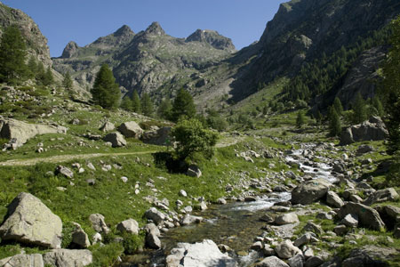
Refuge de Nice from Pont du Gountet
Walk 6057
Country - France
Region - Alpes-Maritimes (06) - Mercantour NP & Côte d'Azur
Author - Lou Johnson
Ascent - 580 metres / 1914 feet
Descent - 580 metres / 1914 feet
Time - 5.00 hours
Grade - moderate
Click image to visit gallery of 12 images.
This excellent walk investigates the upper reaches of the Gordolasque Valley. The start is just over an hours drive from Nice using the N202 to Plan-du-Var and then taking the D2565 towards Lantosque. Continue up the Vesubie Valley and take the D171 to Belvédère and the Gordolasque. Care is needed to make sure you take the correct road immediately prior to Belvédère. From this village the narrow road winds its way up valley to reach a large parking area near the Pont du Gountet (1690m). This is the start of the walk.
The walk starts from sign no. 411 and stays on the west bank of the River Gordolasque. Continue upstream passing some immense boulders, which are used by climbers for bouldering, to reach sign no.413. Cross the river here using the bridge following the signs to Refuge de Nice. Once on the other side bear left and begin to climb beside the stream coming down from Lac Autier. The path crosses this stream (no bridge) so find an easy crossing point near the red painted flashes and continue on the clear well maintained path on the east bank of the main river.
The path climbs in zigzags with the impressive Cascade de l'Estrech on your left. The path steepens to reach a stone wall after which the path levels off beside the river. Continue for a short way and then find a convenient crossing. Cross the river and continue on the path upstream with the river now on your right. The path bear left away from the river and starts to climb through rocky terrain. The route is marked by flashes of paint. After the initial climb the path levels and drops down to a wooden boardwalk across a marshy area before continuing to climb up to the dam now in view ahead.
The path reaches the dam wall and you get your first view of the Lac de la Fous Reservoir with the Refuge de Nice on its north-eastern shore. Continue along the shore path to reach the Refuge (closed for refurbishment in 2008). At the head of the valley are the impressive peaks of Cime du Gélas (3143m) and the Cime de la Malédie (3059m).
The return route follows the outward route back to the point where you last crossed the river. Instead of crossing the river follow the path on the west bank the yellow warning sign draws your attention to the fact that there is short section that requires some scrambling ability. The path is well graded and you soon reach the top of the crag over which the river plunges as the Cascade de l'Estrech. Using a series of zigzags the path cleverly bypasses all major obstacles to arrive at a point where a small stream showers the path on a section that requires hands. More awkward than difficult do expect to get wet as you clamber over the rough steps and handholds cut in the rock. Once you have passed this the path continues in a series of zigzags to reach the bridge by sign no.413.
Cross the bridge and bear right at sign no.413 to follow the clear track following the river downstream on its east bank. This change of scene has its benefits as the retrospective view up the valley is superb and much better than the view from the path used on the other bank at the start of the day. Cross the river at sign no.412 using the Pont du Gountet to reach the car park.
Suggested Maps
 - IGN Carte de Randonnée - Vallée de la Vésubie Parc National du Mercantour - 1:25000 Sheet 3741OT
Stay Safe
Do enjoy yourself when out walking and choose a route that is within your capabilities especially with regard to navigation.
Do turn back if the weather deteriorates especially in winter or when visibility is poor.
Do wear the right clothing for the anticipated weather conditions. If the weather is likely to change for the worse make sure you have enough extra clothing in your pack.
Do tell someone where you are planning to walk especially in areas that see few other walkers.
Do take maps and other navigational aids. Do not rely on mobile devices in areas where reception is poor. Take spare batteries especially in cold weather.
Do check the weather forecast before leaving. The Met Office has a number of forecasts for walkers that identify specific weather risks.
Please Note - These walks have been published for use by site visitors on the understanding that Walking Britain is not held responsible for the safety or well being of those following the routes as described. It is worth reiterating the point that you should embark on a walk with the correct maps preferably at 1:25000 scale. This will enable any difficulties with route finding to be assessed and corrective action taken if necessary.