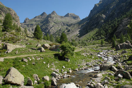
Gordolasque Valley from Pont du Gountet
Walk 6058
Country - France
Region - Alpes-Maritimes (06) - Mercantour NP & Côte d'Azur
Author - Lou Johnson
Ascent - 50 metres / 165 feet
Descent - 50 metres / 165 feet
Time - 1.00 hours
Grade - easy
Click image to visit gallery of 3 images.
This short walk provides an easy introduction to the delights of the Gordolasque Valley with its superb mountain scenery. The start is just over an hours drive from Nice using the N202 to Plan-du-Var and then taking the D2565 towards Lantosque. Continue up the Vesubie Valley and take the D171 to Belvédère and the Gordolasque. Care is needed to make sure you take the correct road immediately prior to Belvédère. From this village the narrow road winds its way up valley to reach a large parking area near the Pont du Gountet (1690m). This is the start of the walk.
The walk starts from sign no. 411 and stays on the west bank of the River Gordolasque. Continue upstream passing some immense boulders, which are used by climbers for bouldering, to reach sign no.413. Cross the river here using the bridge. Once on the other side, bear right to follow the clear track on the east bank of the river. This change of scene has its benefits as the retrospective view up the valley is superb and much better than the view from the path used on the other bank at the start of the day. Cross the river at sign no.412 using the Pont du Gountet to reach the car park.
Suggested Maps
 - IGN Carte de Randonnée - Vallée de la Vésubie Parc National du Mercantour - 1:25000 Sheet 3741OT
Stay Safe
Do enjoy yourself when out walking and choose a route that is within your capabilities especially with regard to navigation.
Do turn back if the weather deteriorates especially in winter or when visibility is poor.
Do wear the right clothing for the anticipated weather conditions. If the weather is likely to change for the worse make sure you have enough extra clothing in your pack.
Do tell someone where you are planning to walk especially in areas that see few other walkers.
Do take maps and other navigational aids. Do not rely on mobile devices in areas where reception is poor. Take spare batteries especially in cold weather.
Do check the weather forecast before leaving. The Met Office has a number of forecasts for walkers that identify specific weather risks.
Please Note - These walks have been published for use by site visitors on the understanding that Walking Britain is not held responsible for the safety or well being of those following the routes as described. It is worth reiterating the point that you should embark on a walk with the correct maps preferably at 1:25000 scale. This will enable any difficulties with route finding to be assessed and corrective action taken if necessary.