Point de Cabbé and Roquebrune
Walk 6059
Country - France
Region - Alpes-Maritimes (06) - Mercantour NP & Côte d'Azur
Author - Lou Johnson
Ascent - 240 metres / 792 feet
Descent - 240 metres / 792 feet
Time - 2.00 hours
Grade - easy/mod
Click image to visit gallery of 12 images.
This circular walk starts from the SNCF railway station at Roquebrune-Cap-Martin which is close to the N7 coastal road. The route includes a section of the coastal path before climbing to the old village of Roquebrune situated about 250m metres above the sea. It is worth obtaining a street map of Roquebrune-Cap-Martin from the tourist office before starting as this will help with navigation. There is plenty of free parking by the station which is also served by frequent trains along the coast linking Nice, Monaco and Menton.
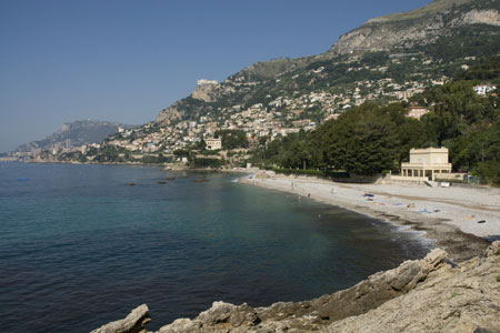
To start the walk, exit the station and make your way down towards the beach. The coastal path follows the railway east and the first section by the station was under reconstruction in 2008 and difficult to locate. However you can still walk down to the sea and turn left along the beach and pick up the coastal path in a few hundred metres. Once on the concrete path continue towards Cap Martin. Shortly after the end of the beach Corbusier's wooden cabin is on your right between the path and sea. (This world renowned architect died after suffering a hear attack in the sea by this cabin.)
The path is a delight offering views across the bay to Monaco. Shortly after a section where the path crosses a metal bridge across a retaining wall look out for a path junction. The coastal path continues bearing right but we go left along the Sentier du Dragonnière. This leads up to Avenue Virginie Heriot. Turn right and then almost immediately left up Avenue General Leclerc to reach the N7 with a Police Station opposite.
Cross the N7 and take the Sentier Pelissier. This climbs uphill to reach the Chemin de Pelissier. Turn right onto this street and then left into the Chemin de Menton. This passes the La Pause and St-Roch chapels to reach the Millennium Olive tree, claimed to be the oldest in the World. Shortly afterwards you reach the old village of Roquebrune, which is worth spending some exploring with its Castle, fine Church and a square (Place des deux Fréres) with superb views over Monaco.
Having explored the village, locate the Escalier Chanone, which descends to the coast by the main door to the church. This series of steps lead you across two main roads (care needed when crossing) down to the railway station.
Suggested Maps
 - IGN Carte de Randonnée - Nice/Menton/Côte d'Azur - 1:25000 Sheet 3742OT
Stay Safe
Do enjoy yourself when out walking and choose a route that is within your capabilities especially with regard to navigation.
Do turn back if the weather deteriorates especially in winter or when visibility is poor.
Do wear the right clothing for the anticipated weather conditions. If the weather is likely to change for the worse make sure you have enough extra clothing in your pack.
Do tell someone where you are planning to walk especially in areas that see few other walkers.
Do take maps and other navigational aids. Do not rely on mobile devices in areas where reception is poor. Take spare batteries especially in cold weather.
Do check the weather forecast before leaving. The Met Office has a number of forecasts for walkers that identify specific weather risks.
Please Note - These walks have been published for use by site visitors on the understanding that Walking Britain is not held responsible for the safety or well being of those following the routes as described. It is worth reiterating the point that you should embark on a walk with the correct maps preferably at 1:25000 scale. This will enable any difficulties with route finding to be assessed and corrective action taken if necessary.