Ritort & Montaimont from Pont de la Pêche, Pralognan
Walk 6069
Country - France
Region - Savoie (73) - Vanoise National Park
Author - Lou Johnson
Ascent - 200 metres / 660 feet
Descent - 200 metres / 660 feet
Time - 2.50 hours
Grade - easy
Click image to visit gallery of 10 images.
This walk is an ideal introduction to the Vanoise National Park in the area around Palognan. Route finding is easy and apart from a couple of sections of uphill walking there are no difficulties to be overcome. The scenery is rugged and there are two opportunities for refreshment during the walk.
The start is at the southern end of the minor road from Pralognan to les Prioux. After passing this hamlet continue to the parking area at the end of the road. This can be a busy area during peak periods and parking could be at a premium. Continue to the top end of the parking area and bear right on a track to descend to a bridge across the River Doron de Chaviere. Cross the bridge and start to climb quite steeply on this stony track.
The steepest section of the climb is soon completed and you are able to enjoy a wonderful view looking back to Pralognan together with an improving prospect ahead. With the track now levelling off you will soon arrive at the refuge du Roc de la Pêche, which is on your right. Just before the refuge is an interesting small chapel that is well worth visiting.
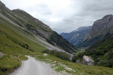
Unless you are hungry or thirsty continue on the main track up the valley. There is no need to rush so enjoy the view with mountains either side on the path. The meadows here see many wild flowers in season and early in the summer there will be plenty of snow remaining on the mountains. You can walk as far as you wish along this path heading deeper into the mountains. However a convenient turning point is Ritort where a limited range of refreshments are available at the small farm.
Turning back down the valley you should retrace your steps as far as the refuge du Roc de la Pêche. Just before reaching the refuge bear half right across a meadow on a clear path. This leads to a small canyon that contains the River Doron de Chaviere The path zigzags steeply down to a metal bridge across the river before climbing up in a similar manner to the small hamlet of Montaimont. The chalets and barns probably still perform their original function.
Reaching a cross path, turn left. This takes you in front of the red roofed barns and then starts to descend back down to the start of the walk. The view ahead is excellent and provides a good finish to the walk.
Suggested Maps
 - IGN Carte de Randonnée - Les Trois Vallees & Modane, Parc National de la Vanoise - 1:25000 Sheet 3534 OT
Stay Safe
Do enjoy yourself when out walking and choose a route that is within your capabilities especially with regard to navigation.
Do turn back if the weather deteriorates especially in winter or when visibility is poor.
Do wear the right clothing for the anticipated weather conditions. If the weather is likely to change for the worse make sure you have enough extra clothing in your pack.
Do tell someone where you are planning to walk especially in areas that see few other walkers.
Do take maps and other navigational aids. Do not rely on mobile devices in areas where reception is poor. Take spare batteries especially in cold weather.
Do check the weather forecast before leaving. The Met Office has a number of forecasts for walkers that identify specific weather risks.
Please Note - These walks have been published for use by site visitors on the understanding that Walking Britain is not held responsible for the safety or well being of those following the routes as described. It is worth reiterating the point that you should embark on a walk with the correct maps preferably at 1:25000 scale. This will enable any difficulties with route finding to be assessed and corrective action taken if necessary.