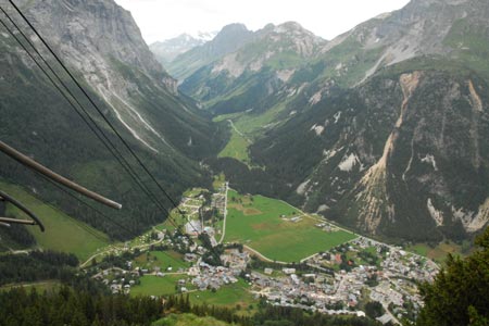
Mont Bochor from Pralognan
Walk 6073
Country - France
Region - Savoie (73) - Vanoise National Park
Author - Lou Johnson
Length - 1.4 km / 0.9 miles
Time - 1.00 hours
Grade - easy
Click image to visit gallery of 5 images.
Mont Bochor offers a grandstand view of Pralognan, the valley and the mountain backdrop. It is most easily reached by taking the cable car from the centre of Pralognan. Operating every 30 minutes the service does break for lunch.
Rather than provide a detailed description of a walk, the intention is to provide some ideas of how this viewpoint can be incorporated into a number of walks. The first possibility includes following the 'sentier decouverte' which visits 10 information tables outlining various aspects of the mountain environment. The length of the trail is about 1400 metres. After completion of the trail you can either return to the valley by cable car or continue by following the other option given below.
The second option involves buying a one way ticket on the cable car with a descent on foot back to the village. The easiest way down is via les Fontanettes. Initially follow the path to the Barmettes refuge and almost immediately turn right and go under the chairlift to loop down through the woods to les Fontanettes. From the parking area the path is signed and goes between two houses before continuing down into the village. The descent by this option takes about an hour.
Suggested Maps
 - IGN Carte de Randonnée - Les Trois Vallees & Modane, Parc National de la Vanoise - 1:25000 Sheet 3534 OT
Stay Safe
Do enjoy yourself when out walking and choose a route that is within your capabilities especially with regard to navigation.
Do turn back if the weather deteriorates especially in winter or when visibility is poor.
Do wear the right clothing for the anticipated weather conditions. If the weather is likely to change for the worse make sure you have enough extra clothing in your pack.
Do tell someone where you are planning to walk especially in areas that see few other walkers.
Do take maps and other navigational aids. Do not rely on mobile devices in areas where reception is poor. Take spare batteries especially in cold weather.
Do check the weather forecast before leaving. The Met Office has a number of forecasts for walkers that identify specific weather risks.
Please Note - These walks have been published for use by site visitors on the understanding that Walking Britain is not held responsible for the safety or well being of those following the routes as described. It is worth reiterating the point that you should embark on a walk with the correct maps preferably at 1:25000 scale. This will enable any difficulties with route finding to be assessed and corrective action taken if necessary.