St Malo to Dinard along the Rance Estuary using GR34
Walk 6076
Country - France
Region - Ille et Vilaine (35) - Brittany
Author - Lou Johnson
Length - 12.0 km / 7.5 miles
Time - 4.00 hours
Grade - easy/mod
Click image to visit gallery of 12 images.
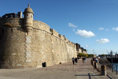
This walk starts from the ramparts of the walled city of St Malo and ends in the fashionable resort of Dinan on the other side of the River Rance Estuary. The route follows long distance footpath GR34 and includes some excellent views and many historical sights.
Start from the quayside by ramparts at the Porte de Dinan (Dinan Gate) in St Malo. This is where you will return if you take the ferry to complete the route. Walk away from the ferry point with the walls on your left. Join the main road to St Servan and cross the locks/bridge across the harbour entrance. Go round the pool and gymnasium and continue past the boats moored in the Bas Sablons marina.
Climb stairs to reach the battlements of the Cité d'Aleth - this rocky peninsula offers a good view of the Rance Estuary from the walled city of St Malo across the river to the seaside resort of Dinard. The Cité I home to some a the few remaining fortifications from the second world war. Descend from the Cité and take le chemin de la Corderie. This leads via a flight of steps to quay of the Port Saint-Père.
Continue along the waterfront past the Solidor Tower, which is now a museum, and walk along the dock and the beach of Saint-Servan. Go past the west front of Holy Cross Church and turn immediately right onto rue Jeanne Jugan. Reaching place de Poncel continue right down to Rosais Beach. Continue by following the river bank upstream to reach the Barrage de la Rance.
Cross the dam using the pedestrian path. On the far side turn right into Avenue de la Rance. Turn right into Rue des Lauriers, right into Avenue du manoir and right again into Avenue du Port. This takes you down to river bank. Turn left on the Chemin de Ronde coastal path (with the sea on your right) along the coast around the Pointe de la Jument and the Pointe de la Vicomte. This section offers some panaoramic views of the estuary.
At the Priory Beach (Plage die Pieure) continue north on the Promenade du Clair de Lune with its tropical plants which reflect the mild climate of the resort. Before taking the ferry across the Rance, it is worth spending some time exploring Dinan with its many fine Victorian Gothic villas. The pier in use for ferries to St Malo does change depending on tides. However notices show the place where the ferry is currently loading. Note the ferry only operates in season and during the remainder of the year you will need to use the bus service which starts near the Tourist Office in Dinan.
Suggested Maps
 - IGN Carte de Randonnée - St-Malo, Dinard, Dinan - 1:25000 Sheet 1116 ET
Stay Safe
Do enjoy yourself when out walking and choose a route that is within your capabilities especially with regard to navigation.
Do turn back if the weather deteriorates especially in winter or when visibility is poor.
Do wear the right clothing for the anticipated weather conditions. If the weather is likely to change for the worse make sure you have enough extra clothing in your pack.
Do tell someone where you are planning to walk especially in areas that see few other walkers.
Do take maps and other navigational aids. Do not rely on mobile devices in areas where reception is poor. Take spare batteries especially in cold weather.
Do check the weather forecast before leaving. The Met Office has a number of forecasts for walkers that identify specific weather risks.
Please Note - These walks have been published for use by site visitors on the understanding that Walking Britain is not held responsible for the safety or well being of those following the routes as described. It is worth reiterating the point that you should embark on a walk with the correct maps preferably at 1:25000 scale. This will enable any difficulties with route finding to be assessed and corrective action taken if necessary.