Le Percy from Clelles
Walk 6079
Country - France
Region - Isere (38) - Parc Naturel Régional du Vercors
Author - Lou Johnson
Length - 9.0 km / 5.6 miles
Ascent - 100 metres / 330 feet
Descent - 100 metres / 330 feet
Grade - easy
Click image to visit gallery of 12 images.
Starting from the small commune of Clelles, the walk offers a quiet ramble with some excellent views to the western flank of the Ecrins National Park. Using a mixture of tracks and public roads the walking is easy and relaxing. Note that there are drinks and food in Clelles but nowhere else on the walk.
Start from the square in the centre of Clelles. Follow the road (D252) leading to the N75 south. After just over half a kilometre you reach Teysonnieres where you take the track forking left. This leads across country to Pontou in a further 1.4 kilometres. Turn left here for Longefonds which you soon reach by the church.
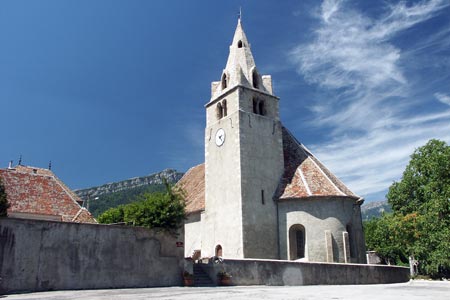
Turn right onto the minor road. Quickly reaching a t-junction take the track opposite. This leads to Les Bachats where you join the road again for the last section into Le Percy with its fine church domination the scene. The village has many fine buildings typical of the area and offers a fine view east towards the Ecrins.
The return route follows the outward walk.
Suggested Maps
 - IGN Carte de Randonnée - Villard-de-Lans, Mont Aguille, PNR du Vercors - 1:25000 Sheet 3236 OT
- Promenades et Randonnees - Le Trieves: Autour de Clelles. Available in the excellent Tourist Office in Clelles.
Stay Safe
Do enjoy yourself when out walking and choose a route that is within your capabilities especially with regard to navigation.
Do turn back if the weather deteriorates especially in winter or when visibility is poor.
Do wear the right clothing for the anticipated weather conditions. If the weather is likely to change for the worse make sure you have enough extra clothing in your pack.
Do tell someone where you are planning to walk especially in areas that see few other walkers.
Do take maps and other navigational aids. Do not rely on mobile devices in areas where reception is poor. Take spare batteries especially in cold weather.
Do check the weather forecast before leaving. The Met Office has a number of forecasts for walkers that identify specific weather risks.
Please Note - These walks have been published for use by site visitors on the understanding that Walking Britain is not held responsible for the safety or well being of those following the routes as described. It is worth reiterating the point that you should embark on a walk with the correct maps preferably at 1:25000 scale. This will enable any difficulties with route finding to be assessed and corrective action taken if necessary.