Pas de l'Aiguille & Refuge de Chaumailloux from Les Forcheaux
Walk 6085
Country - France
Region - Isere (38) - Parc Naturel Régional du Vercors
Author - Lou Johnson
Length - 5.0 km / 3.1 miles
Ascent - 420 metres / 1386 feet
Descent - 420 metres / 1386 feet
Grade - easy/mod
Click image to visit gallery of 6 images.
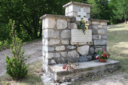
This walk is a shorter version of walk 6077 and offers an easier way of enjoyong a dramatic section of the Vercors limestone plateaux and mountains in the départements of Isère south of Grenoble. The area does not have National Park status instead being a Regional Natural Park. The highest point of the Vercors is Grand Veymont (2346m) although its most memorable peak is Mont Aiguille (2086m), which is seen during this walk. During the Second World War the resistance established the Free Republic of Vercors during 1944 and this walk includes two monuments to those resistance fighters.
The start of the walk is the car park at Les Forcheaux which lies west of the N75 Grenoble to Veynes main road near Richardiere. There is some signage directing drivers to the Pas de l'Aiguille from near the main road. The drive to the start will introduce you to scenery that is typical of the area including your first view of Mont Aiguille. The final section to the car park is on a gravel track that starts just after Richardiere. After parking you can inspect the first monument to the Resistance before following the path to start the scent onto the plateau. Surrounded by limestone cliffs, the path twists and turns. In 1.5km you ascend 400 metres to reach the Pas de l'Aiguille where the second memorial is located.
The terrain from here is at best confusing across an undulating limestone plateau. If you are content to explore the area in the immediate vicinity of the Pas de l'Aiguille then a map is not necessary. However if you wsih to explore further onto the plateau then remember that it is difficult to orientate and you need the recommended map to continue. From the Pas de l'Aiguille the path follows a shallow valley to reach a junction of paths at the Refuge de Chaumailloux. By bearing left here you can climb uphill to gain a vantage point with an excellent view of Mont Aiguille.
To return to the start follow the outward route. Do take care in descent as the path can be quite tricky underfoot especially after rain.
Suggested Maps
 - IGN Carte de Randonnée - Glandasse, Col de ka Croix-haute, PNR du Vercors - 1:25000 Sheet 3237 OT
- Promenades et Randonnees - Le Trieves: Autour de Clelles. Available in the excellent Tourist Office in Clelles.
Stay Safe
Do enjoy yourself when out walking and choose a route that is within your capabilities especially with regard to navigation.
Do turn back if the weather deteriorates especially in winter or when visibility is poor.
Do wear the right clothing for the anticipated weather conditions. If the weather is likely to change for the worse make sure you have enough extra clothing in your pack.
Do tell someone where you are planning to walk especially in areas that see few other walkers.
Do take maps and other navigational aids. Do not rely on mobile devices in areas where reception is poor. Take spare batteries especially in cold weather.
Do check the weather forecast before leaving. The Met Office has a number of forecasts for walkers that identify specific weather risks.
Please Note - These walks have been published for use by site visitors on the understanding that Walking Britain is not held responsible for the safety or well being of those following the routes as described. It is worth reiterating the point that you should embark on a walk with the correct maps preferably at 1:25000 scale. This will enable any difficulties with route finding to be assessed and corrective action taken if necessary.