Fort de la Latte to Cap Fréhel
Walk 6094
Country - France
Region - Côtes-d'Armor (22) - Brittany
Author - Lou Johnson
Time - 3.00 hours
Grade - easy
Click image to visit gallery of 12 images.
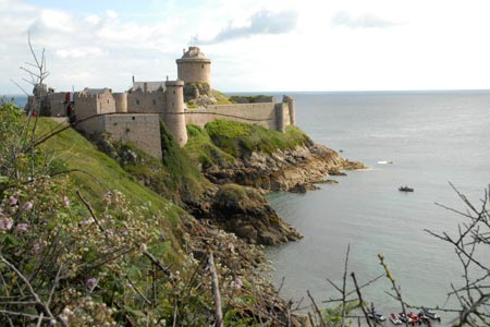
The coast in this area is spectacular with high cliffs and a rocky seascape. At the time of the visit in early July there was an abundance of colour with wild flowers, yellow gorse and heather in abundance. The start of the walk is the free car park intended for visitors to the privately owned Fort de la Latte located at the end of the D117. This road leaves the main D786 from the hamlet of Ste. Aide a few kilometres east of the village Fréhel. The walk follows a section of the long distance footpath GR34 or Sentier des Douaniers along the beautiful Brittany coastline.
After parking follow the wide track down towards the Fort. Ignore the sign pointing to the G34 near the car park and stay on the wide track. You get an excellent view of this fortification as you descend towards the sea. Reaching the entrance gates to the Fort you will see the GR34 signed on your left. Initially the path is hemmed in by high vegetation although there are a few places where you get an excellent view of the Fort and views ahead to Cap Fréhel with the lighthouse providing an excellent landmark.
Despite the initial enclosed nature of the path the vegetation soon changes and you have open views along the rocky coast with its high cliffs to Cap Fréhel. The route is always clear and the path generally well maintained. Continue along GR34 and continue past the restaurant and lighthouse to reach the rocky Cape.
To return to the start it is probably best to continue to the lighthouse where exhibitions are held form time to time. It is also I think possible to visit the lighthouse. There are a number of paths leading back to the cliff top path and you soon rejoin the outward route.
The out and back walk took about 3 hours at a leisurely pace. The restaurant at Cap Fréhel offers a wide range of meals. Refreshments are also available near the car park.
Suggested Maps
 - IGN Carte de Randonnée - St-Cast-le-Guildo & Cap Fréhel - 1:25000 Sheet 1116 ET
Stay Safe
Do enjoy yourself when out walking and choose a route that is within your capabilities especially with regard to navigation.
Do turn back if the weather deteriorates especially in winter or when visibility is poor.
Do wear the right clothing for the anticipated weather conditions. If the weather is likely to change for the worse make sure you have enough extra clothing in your pack.
Do tell someone where you are planning to walk especially in areas that see few other walkers.
Do take maps and other navigational aids. Do not rely on mobile devices in areas where reception is poor. Take spare batteries especially in cold weather.
Do check the weather forecast before leaving. The Met Office has a number of forecasts for walkers that identify specific weather risks.
Please Note - These walks have been published for use by site visitors on the understanding that Walking Britain is not held responsible for the safety or well being of those following the routes as described. It is worth reiterating the point that you should embark on a walk with the correct maps preferably at 1:25000 scale. This will enable any difficulties with route finding to be assessed and corrective action taken if necessary.