Fedaia Lake from Canazei (via Porta Vescovo)
Walk 6108
Country - Italy
Region - Dolomites - Val de Fassa
Author - Dolomites Inn, Penia near Canazei
Time - 4.50 hours
Grade - moderate
Click image to visit gallery image.
This walk starts in the busy resort of Canazei. Locate the large car park opposite the cable car station and take the gondolas to Pecol where you continue by cable car to the Col di Rossi. It is worth spending a few minutes enjoying the view with the large mountains either side of the Sella Pass in view together with many of the mountains, ridges and valleys that make up the Val de Fassa.
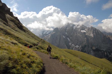
From the top station of the cable car follow the signs "Viel de Pan" (path 601). At first this is a broad track which you leave at the first junction where you veer right and slightly uphill towards the mountain hut Fredarola which is reached after 20 minutes. Continuing on the clear path, the Rifugio Viel de Pan is the next objective which should be reached after an hours walking. The view to the right of this path is superb with the Marmolada Massif dominant across the valley with Lake Fedaia already in view at the foot of this mountain.
Leaving the Rigugio de Pan continue on the main path which clings to the side of the mountain on the next section. Despite the drop to your right, the path is not difficult and provided you take care you should meet with no problems. The path rises to the Col de Paussa from where there are excellent views down to Arabba. After leaving the Col the path crosses a shoulder and reaches a clear junction. Path 601 continues ahead but you must bear left for Porta Vescovo
At the col you will find the Rifugio Porto Vescovo (roughly 2 hours from the start). On this part of the walk towards the end of June and early July it is possible to see the beautiful blue flower,' King of the Alps' (quite rare) growing on the black volcanic rock. Also many other flowers such as the sulphur anemone can be seen on this section. From the Refuge (located at the top of the Arabba to Porto Vescovo cable car) take a look at the splendid views on the north side of the ridge towards the Piz Boe and Tofane towards Cortina with the Marmolada glacier on the opposite side of Lake Fedaia.
So far the walk has been on a path that has varied in height between the Col di Rossi and Porto Vescovo between 2300 and 2500 metres. From Porto Vescvo we need to lose over 400 metres taking path 698 for the descent to Lake Fedaia (2053 m). During the descent you are constantly reminded of the Marmolada glacier which lies directly across the valley.
Reaching the road by Lake Fedaia you can take the bus to Canazei. Check departure times before starting the walk. There is a regular service but also some parts of the day where a two hour interval between buses needs to be taken into account. Note there are places to eat near the bus stop. As an alternative you can walk down the valley to Penia on path 605. This takes around 90 minutes passing the Rifugio Viletta Maria on the way to the typical Alpine village of Penia. From here you can continue to walk to Canazei or take advantage of the more frequent bus service.
Suggested Maps
 - Val di Fassa e Dolomiti Fassane - 1:25000 scale - sheet 06 published by Tabacco
Stay Safe
Do enjoy yourself when out walking and choose a route that is within your capabilities especially with regard to navigation.
Do turn back if the weather deteriorates especially in winter or when visibility is poor.
Do wear the right clothing for the anticipated weather conditions. If the weather is likely to change for the worse make sure you have enough extra clothing in your pack.
Do tell someone where you are planning to walk especially in areas that see few other walkers.
Do take maps and other navigational aids. Do not rely on mobile devices in areas where reception is poor. Take spare batteries especially in cold weather.
Do check the weather forecast before leaving. The Met Office has a number of forecasts for walkers that identify specific weather risks.
Please Note - These walks have been published for use by site visitors on the understanding that Walking Britain is not held responsible for the safety or well being of those following the routes as described. It is worth reiterating the point that you should embark on a walk with the correct maps preferably at 1:25000 scale. This will enable any difficulties with route finding to be assessed and corrective action taken if necessary.