Cirque de Gavarnie from Col des Tentes nr. Gavarnie
Walk 6112
Country - France
Region - Haute Pyrenees (65)
Author - Mountainbug Holidays
Time - 4.00 hours
Grade - moderate
Click image to visit gallery of 3 images.
This walk is based in the French Pyrenees - a wonderful area for walking and to discover the unspoilt mountain culture of Southern France. The Pyrenees have a whole host of endemic animals and flowers all living within an incredibly beautiful landscape.
The walk described takes in the towering cliffs of the Cirque de Gavarnie, the Grande Cascade (the highest waterfall in Europe) and the incredible Breche de Roland pass into Spain and the Ordessa National Park - some of the most famous landmarks in the Pyrenees.
This walk is an easy way to see all the views without the huge climb required from the valley bottom. The Cirque de Gavarnie is located at the Spanish frontier, at the end of the Vallee des Gaves (with the town of Lourdes at its mouth). The area has some fantastic walking, and is best accessed by a Ryanair flight into Pau. Accommodation and guided walking with qualified European mountain leaders is available through Mountainbug Holidays, www.mountainbug.com
Directions: From the village of Gavarnie, drive up the ski road to the parking at the Col de Tentes (2208m). From here, follow the old col road on foot to the Port de Boucharo (2270m) and the Spanish border. The path skirts right, above the Pouey Aspe valley, and looks down onto mountain pastures and old bergers' cabins.
At the end of the valley, the path turns into an easy scramble beside a cascading stream. The route is cairned but can be a little confusing. Follow your nose - all paths lead to the Col des Sarradets, with spectacular views of the Cirque de Gavarnie and the legendary Grande Cascade.
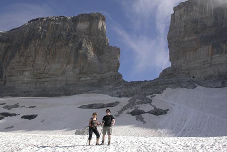
Just below the col, the Sarradets refuge is a great lookout point for a snack and a coffee. The path climbs above the refuge to the Br%egrave;che de Roland (2807m), crossing a small glacier (an easy snow crossing in summer, but may require crampons early in the season). The Brèche is an awesome slash in the frontier cliffs - a window to Spain and the Ordessa National Park.
From the Brèche there is the option of ascending the most accessible of the Pyrenean 3000m peaks - Le Taillon (3144m), which will add about 2hrs to the walk. Descend via the same route, or (if on foot and not tied into picking up your car!) drop into the Pouey Aspe valley via a series of zig zags below the stream scramble, and back to the village of Gavarnie.
Suggested Maps
 - IGN Carte de Randonnée - Gavarnie - Luz-St-Saveur - 1:25000 Sheet 1748OT
Stay Safe
Do enjoy yourself when out walking and choose a route that is within your capabilities especially with regard to navigation.
Do turn back if the weather deteriorates especially in winter or when visibility is poor.
Do wear the right clothing for the anticipated weather conditions. If the weather is likely to change for the worse make sure you have enough extra clothing in your pack.
Do tell someone where you are planning to walk especially in areas that see few other walkers.
Do take maps and other navigational aids. Do not rely on mobile devices in areas where reception is poor. Take spare batteries especially in cold weather.
Do check the weather forecast before leaving. The Met Office has a number of forecasts for walkers that identify specific weather risks.
Please Note - These walks have been published for use by site visitors on the understanding that Walking Britain is not held responsible for the safety or well being of those following the routes as described. It is worth reiterating the point that you should embark on a walk with the correct maps preferably at 1:25000 scale. This will enable any difficulties with route finding to be assessed and corrective action taken if necessary.