Pico de Vilo from Alfarnate
Walk 6126
Country - Spain
Region - Malaga Province (Andalucia)
Author - Peter Bailey
Length - 11.2 km / 7 miles
Ascent - 500 metres / 1650 feet
Descent - 500 metres / 1650 feet
Time - 4.00 hours
Grade - moderate
Click image to visit gallery of 4 images.
Alfarnate is a typical Spanish village in a delightful location which has really not been touched by tourism. This is a linear walk starting and ending in the village. There are very good views throughout.
How to get to the start : Alfarnate is really only accessible by car. Take the motorway going north from Malaga. When you reach Casabermeja, leave the motorway and follow signs for Rio Gordo and Alfarnate.
The walk Start from the municipal sportsground, signed "Polideportivo", from the centre of the village. This is located on the southern edge of the village and close to the mountain. Walk towards the Pico de Vilo mountain along an unsurfaced stony road which is wide enough to drive along in a car. As the path zigzags up the mountain you will have excellent views of Alfarnate in the wide valley below. From time to time you will see the TV tower on the shoulder of the hill in front of you.
When you reach the TV tower, follow the main path round to the left. Gradually climbing parallel to the mountain ridge. On your right you will have spectacular views of the mountains south of Villanueva del Rosario, although the village itself is concealed behind the mountains. Even more impressive are the views of the Tajo del Fraile , Gómer and Do&ncirc;a Ana. You follow the main path practically to the end. Eventually Alfarrnatejo village comes into sight far below on the right.
When you have walked more than 3 km (approx 2 miles) you reach a much narrower path climbing up the hillside to the left. The main path leads down to a farm from here. Our path soon leads through pine woods and when you reach the ridge, you will see a circular threshing area made from stones, "era" in Spanish. From this point on the ridge the path leads upwards towards the right, or generally south. A hundred yards after the threshing area you reach a fence, which you cross and follow the line of another fence to your right. The path is sometimes a little indistinct but you are always going uphill.
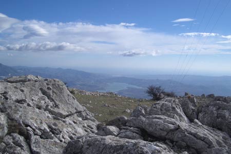
Eventually you emerge from the wood. From this point you can see the highest point of El Pico de Vilo and you make for that. You are now in a wide open area and it is clearly possible to find your own path without any danger of getting lost. There are one or two signs indicating where the path is but do not worry if you miss them, you cannot get lost if you bear in mind that you are always heading for the highest ground. Soon you will see another TV or radio mast on the highest point of the Pico. Head towards this and enjoy the view across the valleys over towards Lake Vi&numl;uela and in the distance the sea. The return route is the same as the ascent.
Stay Safe
Do enjoy yourself when out walking and choose a route that is within your capabilities especially with regard to navigation.
Do turn back if the weather deteriorates especially in winter or when visibility is poor.
Do wear the right clothing for the anticipated weather conditions. If the weather is likely to change for the worse make sure you have enough extra clothing in your pack.
Do tell someone where you are planning to walk especially in areas that see few other walkers.
Do take maps and other navigational aids. Do not rely on mobile devices in areas where reception is poor. Take spare batteries especially in cold weather.
Do check the weather forecast before leaving. The Met Office has a number of forecasts for walkers that identify specific weather risks.
Please Note - These walks have been published for use by site visitors on the understanding that Walking Britain is not held responsible for the safety or well being of those following the routes as described. It is worth reiterating the point that you should embark on a walk with the correct maps preferably at 1:25000 scale. This will enable any difficulties with route finding to be assessed and corrective action taken if necessary.