Circular walk From Morgins to Tovassiere
Walk 6130
Country - France
Region - Haute Savoie (74) - Morzines, Samoëns & Abondance
Author - Donald Morton
Ascent - 350 metres / 1155 feet
Descent - 350 metres / 1155 feet
Time - 3.00 hours
Grade - easy/mod
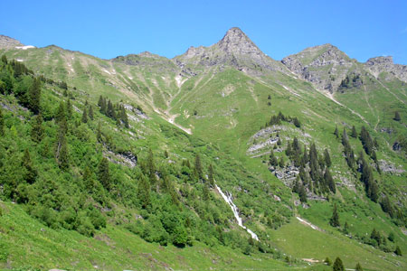
Click image to visit gallery of 8 images.
The car may be parked opposite the riding stables at the start of the Sentier Planetaire, in Morgins (1333m), by a sign advertising the Restaurant d'Alpage de Tovassiere.
Start by walking away from the village up the tarmac Sentier Planetaire. Almost immediately fork left on the Chemin des Ponts heading to Sassex, Portes de Soleil, les Crosets. This path follows the rushing river first on one side and then on the other, crossing numerous small wooden bridges (hence the name of the path) as you make your way upstream. Each bridge, however small, has a plaque uniquely naming it after a plant. In the early part of the walk there are several covered picnic huts. You will also find from time to time information boards on the life cycle of bees and associated topics. At one point the path comes close to the road, but the Chemin des Ponts, signed to Tovassiere, continues along the side of the river. It does eventually come out onto the road and here turn left.
Almost immediately fork left again through the grounds of a small refreshment establishment (En Tey). The path is signed to many places including Lac de Chesery. At a fork continue straight on, to arrive at a little lake. Skirt round this and continue on the Chemin des Ponts. When this comes out onto a forest road at the end of tarmac turn left along the gravel road. At a junction turn right, still following the river. After passing more bee information points and crossing two bridges in quick succession, a sign announces your arrival at Sassex (1514m). The path comes out to tarmac.
Turn left and immediately left on a path signed to La Tovassiere. Cross the river and swing left. From here the path is much steeper as it winds its way from the river, up through the trees to arrive at an Alpine meadow through a turnstile (really!). From here it is a short distance to Cantine de Tovassiere (1689m) - in the summer open July and August for refreshments - situated in a magnificent bowl of mountains. After passing this hut you reach a sign pointing down a road to Morgins 1hr 10 mins. This road is actually the far end of the Sentier Planetaire and, after passing two waterfalls and the path up to Lac de Chesery, as you follow it down to Morgins you will discover the reason why - and improve your knowledge of the planetary system.
Although there is a climb of about 350 m, the ascent is easy until the final stretch up to La Tavossiere. It is an ideal family walk which should be accomplished within three hours or so, with plenty of shade in hot weather, opportunities for refreshment, interesting information points and in clear weather fine views; more energetic members of the party can continue up to Lac de Chesery.
Suggested Maps
 - IGN Carte de Randonnée - Morzine/Massif-du-Chablis/Les Portes du Soleil - 1:25000 Sheet 3528ET
Stay Safe
Do enjoy yourself when out walking and choose a route that is within your capabilities especially with regard to navigation.
Do turn back if the weather deteriorates especially in winter or when visibility is poor.
Do wear the right clothing for the anticipated weather conditions. If the weather is likely to change for the worse make sure you have enough extra clothing in your pack.
Do tell someone where you are planning to walk especially in areas that see few other walkers.
Do take maps and other navigational aids. Do not rely on mobile devices in areas where reception is poor. Take spare batteries especially in cold weather.
Do check the weather forecast before leaving. The Met Office has a number of forecasts for walkers that identify specific weather risks.
Please Note - These walks have been published for use by site visitors on the understanding that Walking Britain is not held responsible for the safety or well being of those following the routes as described. It is worth reiterating the point that you should embark on a walk with the correct maps preferably at 1:25000 scale. This will enable any difficulties with route finding to be assessed and corrective action taken if necessary.