An easy walk round Reynes
Walk 6131
Country - France
Region - Pyrenees Orientales (66)
Author - Peter Schofield
Length - 12.0 km / 7.5 miles
Grade - easy/mod
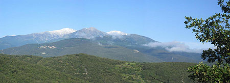
Click image to visit gallery of 3 images.
Considered by many to be the symbol of Catalan identity, 2785m Canigou dominates the eastern end of the Pyrenees. Although this walk is nowhere near as demanding as those in the Central Pyrenees, it nevertheless offers fine views of both Canigou and its neighbours. Furthermore, the availability of public transport from Perpignan and the coast makes it accessible for those without their own transport. What better way to spend a day off from a beach holiday?
The walk starts at le Pont de Reynes on the D115 road about 2K west of the small town of Ceret. From the bus stop near the boulangerie, walk up the Chemin de las Quintanes on the east side of the rushing Ribera stream for just over a kilometre. At a point where the road widens opposite the Impasse des Iris, turn left and follow a broad track as it climbs through the woods of the Serra Den Carol. The woods slowly give way to an area of vines as the track levels out.
Continue along the clear track to a small building covered in flowers and displaying a homily dedicated to the beauty of the area, an appropriate place in view of the expansive panorama looking towards Canigou. At the track junction adjacent to the building, go right on a track as it winds its way on the level for a kilometre to another junction, where views open out to the east towards the Mediterranean. Turn right down this track which turns to tarmac after a short distance.
Follow the tarmac lane as it first ascends for a short distance and then descends past a number of houses along an obvious route to arrive at the junction with the Chemin de las Quintanes which was the road we followed at the start of the walk. Don't go down the Chemin but instead turn sharp left and descend down the Route d'Als Androuix to a bridge over the Ribeca stream which at this point rushes over a series of waterfalls. Below the modern road bridge, an ancient packhorse bridge can be seen.
The lane climbs for a short distance beyond the bridge and after 200m go left on a track signed to Mas Santol. Go up the track where after passing the house, it descends to turn sharp left at a way marker after 100m. The path descends along the edge of a large cherry orchard to cross the Sant stream below a large house called Mas Casals.
The route continues straight ahead to enter an area of woodland which climbs to arrive at a track opposite a house where there are more mountain views to the south. Turn right up the track which after a couple of hundred metres arrives at a bend on a tarmac lane. Go right on to the quiet lane as it descends steeply past a number of houses to reach the main crossroads in the centre of the village of Reynes.
In common with many villages in France, Reynes has a mairie of a size which seems quite out of proportion to the size of the community which it serves. Sadly, what it doesn't have is a bar which given the hot weather on the day that I did the walk would have been more than welcome! To continue, go down the track below the entrance road to the mairie's car park as it firstly crosses a small stream and then gently climbs through woodland for about 1.5K to arrive at a road.
Go along the road for 100m and then turn right on to a broad track which is followed for about 2Kalong the ridge of the Serra Cantaire as more mountain views open out to the west towards Amelie-les-Bains and the Tech valley. Route finding is generally easy where the only point at which care needs to be taken is at a junction after 1.1K where our route ascends to the left. The track continues past a fenced enclosure to reach another junction after another 900m where the track starts to descend. At this point bear right to arrive at a vehicle turning area after 100m.
From this point, the track turns into a path as it continues along the left hand side of an enclosure before descending steeply through the woods above le Pont de Reynes. Route finding is easy as the path finally arrives at a housing estate at the edge of the village. Go through the gate and after 100m turn right opposite the village school where another road junction is reached after 100m. Turn left to arrive at the D115 and the start of the walk after 150m.
Le Pont de Reynes is served by buses on the route between Perpignan, Ceret and Arles sur Tech, and full details of schedules (in French) can be found at www.cg66.fr/routes_transports/transports/bus/index.html. Just 2K east along the road from the start, Ceret itself is well worth a visit, boasting a fine museum of modern art which includes works by such luminaries as Picasso, Chagall, Matisse and Miro as well as the usual refreshment spots.
Suggested Maps
 - IGN Carte de Randonnée - Ceret/Amelie-les-Bains/Palalda/Vallee du Tech - 1:25000 Sheet 2449OT
Stay Safe
Do enjoy yourself when out walking and choose a route that is within your capabilities especially with regard to navigation.
Do turn back if the weather deteriorates especially in winter or when visibility is poor.
Do wear the right clothing for the anticipated weather conditions. If the weather is likely to change for the worse make sure you have enough extra clothing in your pack.
Do tell someone where you are planning to walk especially in areas that see few other walkers.
Do take maps and other navigational aids. Do not rely on mobile devices in areas where reception is poor. Take spare batteries especially in cold weather.
Do check the weather forecast before leaving. The Met Office has a number of forecasts for walkers that identify specific weather risks.
Please Note - These walks have been published for use by site visitors on the understanding that Walking Britain is not held responsible for the safety or well being of those following the routes as described. It is worth reiterating the point that you should embark on a walk with the correct maps preferably at 1:25000 scale. This will enable any difficulties with route finding to be assessed and corrective action taken if necessary.