Circular walk from Lac de Vonnes, Chatel, to Lac de Morgins
Walk 6133
Country - France
Region - Haute Savoie (74) - Morzines, Samoëns & Abondance
Author - Donald Morton
Grade - easy/mod
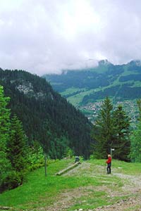
Click image to visit gallery of 4 images.
Going out of Chatel driving up towards Switzerland one comes across Lac des Vonnes on the left about 1km from the church. There are a number of car parks here to leave the car, before starting this walk.
Opposite the lake is a small chapel and the walk starts off from the highway, up the road with the chapel on the left (signed L'Aity d'en Haut 35 mins). Follow the tarmac road until it becomes gravel and crosses the bridge. After the bridge take the left track going up hill, with views of Les Boudimes across the valley, keeping to the broad main track until reaching L'Aity d'en Haut. Just after the hut turn left (Pas de Morgins 45 mins) and then after about 100 m turn left again, sharp back (Pas de Morgins now 40 mins).
The path continues up, accompanied by bird song. Continue straight on ignoring one path on right "sans issue" and a second signed Pointe du Midi. The path is now going downhill and soon after appears to terminate. Actually, it goes off to the left and what had been a broad easy track, becomes much narrower with a steep drop off for a short section, a sharper descent and rougher walking; also slippery if wet. It broadens out as it enters a wood, becomes less steep and in the main less rough but still slippery if wet. After ignoring a path coming in from the right you reach the main road at Pas de Morgins and Lac de Morgins on the border with Switzerland and fine views over the lake and down towards Chatel.
Cross the road and follow the path signed Lac de Vonnes, immediately passing a wayside shrine on the right, which runs more or less parallel to the road on the left. After passing a track on the right invitingly signed Aire de Pique Nique, the track almost rejoins the road; here go straight on using the track on the right. After passing a gated enclosure on the left, fork left all the time following the Lac de Vonnes signs. Again the bird song can be quite noticeable as the track zigzags down to the apex of a sharp bend on the highway. Do not join it but go down some shallow steps to walk parallel to but below the road on the left. The track soon goes away from the road and zigzags down to the lake. When it reaches a tarmac drive go straight on and pass the lake on the right to come back to the car park.
Suggested Maps
 - IGN Carte de Randonnée - Morzine/Massif-du-Chablis/Les Portes du Soleil - 1:25000 Sheet 3528ET
Stay Safe
Do enjoy yourself when out walking and choose a route that is within your capabilities especially with regard to navigation.
Do turn back if the weather deteriorates especially in winter or when visibility is poor.
Do wear the right clothing for the anticipated weather conditions. If the weather is likely to change for the worse make sure you have enough extra clothing in your pack.
Do tell someone where you are planning to walk especially in areas that see few other walkers.
Do take maps and other navigational aids. Do not rely on mobile devices in areas where reception is poor. Take spare batteries especially in cold weather.
Do check the weather forecast before leaving. The Met Office has a number of forecasts for walkers that identify specific weather risks.
Please Note - These walks have been published for use by site visitors on the understanding that Walking Britain is not held responsible for the safety or well being of those following the routes as described. It is worth reiterating the point that you should embark on a walk with the correct maps preferably at 1:25000 scale. This will enable any difficulties with route finding to be assessed and corrective action taken if necessary.