A ridge walk from Col de Bassachaux
Walk 6135
Country - France
Region - Haute Savoie (74) - Morzines, Samoëns & Abondance
Author - Donald Morton
Ascent - 310 metres / 1023 feet
Descent - 310 metres / 1023 feet
Time - 3.50 hours
Grade - easy/mod
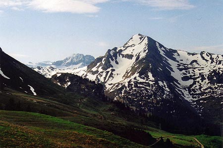
Click image to visit gallery of 10 images.
This walk as described starts from the car park at the Col de Bassachaux (1778m). This is at the end of the D228 running south from Chatêl, in the Vallée d'Abondance, one of the dozen or so communities making up the Portes du Soleil. (Map IGN 3528ET)
It is an interesting ridge walk, with extensive views of the French and Swiss Alps, and running either side of the Col. This means that it is a figure of eight, with the advantage that, in season, refreshment can be taken at the Col at the end of each half. It also means that each half can be done separately as a shorter walk, the section over the Tête des Lindarets taking about 1hr 30 mins (ascent 178m) and the section along the Arête des Fours taking maybe a couple of hours (ascent about 130m). For those who think a ridge walk should start at one end and not in the middle or believe it should be a reward for climbing up, it is possible to walk up from the car park at Plain Dranse by following the broad track up to the left of the chapel, turning right at a cross path, to join the walk at Les Rochassons (see below); this adds about 200m ascent but saves petrol.
Tête des Lindarets section.
The road at Col de Bassachaux curves left into the parking area. Walk through the parking area below the restaurant and continue on the gravel forest road (GR5 indicated by a red and white marker on a tree to the right). Follow the forest road to La Lambe. (From time to time there are information boards in French and English! about the local bird life.) At La Lambe fork left, signed Tête des Lindarets 45 mins. and follow the broad track up to Les Rochassons. Here turn left signed Tête de Lindarets 25 mins. Follow the broad track until, just after a metal cabin with an aerial, a track forks right to the Tête de Lindarets (1950 m). In the spring you walk through spring flowers, and up to the middle of June maybe some snow; later in the year there are wild azaleas and myrtles along the way. (Since they may have been contaminated by wild animals the local medical advice is not to eat unwashed.) The single track continues down the ridge and back to the Col.
Ar&ecird;te des Fours section.
From the car park at Col de Bassachaux take the path at the lowest right hand corner, signed to Col de Coutis. Almost immediately it splits; take the left hand fork through open heath land with lots of spring flowers. This path rises to the Pointe de Lens (1827m) where it turns sharp left to descend through myrtles and wild azaleas. (Just at this point the path may in early season be obscured by the myrtle plants but there are really not many options and it soon becomes clear.) The pines become thicker until you start climbing again to emerge at the start of the Arête des Fours, the narrow ridge leading up to the Pointe des Lanches (1863m) with good views of the Pointe de la Chavache ahead, the Chalets de Lens down in the valley with Mont de Grange beyond.
Beyond the peak the path continues down the (now broader) ridge to the Col de Coutis (1813m). Just before reaching it there is a marker post, currently in a bad state of repair but with boards propped up against it mentioning Les Lindarets and Ardent. Here fork left to reach another post at the actual Col. Turn left, signed Les Lindarets and Ardent. The path winds down the valley. It was from here that we first heard the shrill cries of, and then spotted, a group of marmots among rocks up on the slopes of Pointe de la Chavache. After traversing a lightly wooded area and some bushes the path swings right to arrive at the head of the valley stream and another marker post in bad condition. Here turn left and follow what is now a clear path - 5 years ago it was no more than an unsigned cow path - going with the contours to rise gently back to the Col de Bassachaux.
Suggested Maps
 - IGN Carte de Randonnée - Morzine/Massif-du-Chablis/Les Portes du Soleil - 1:25000 Sheet 3528ET
Stay Safe
Do enjoy yourself when out walking and choose a route that is within your capabilities especially with regard to navigation.
Do turn back if the weather deteriorates especially in winter or when visibility is poor.
Do wear the right clothing for the anticipated weather conditions. If the weather is likely to change for the worse make sure you have enough extra clothing in your pack.
Do tell someone where you are planning to walk especially in areas that see few other walkers.
Do take maps and other navigational aids. Do not rely on mobile devices in areas where reception is poor. Take spare batteries especially in cold weather.
Do check the weather forecast before leaving. The Met Office has a number of forecasts for walkers that identify specific weather risks.
Please Note - These walks have been published for use by site visitors on the understanding that Walking Britain is not held responsible for the safety or well being of those following the routes as described. It is worth reiterating the point that you should embark on a walk with the correct maps preferably at 1:25000 scale. This will enable any difficulties with route finding to be assessed and corrective action taken if necessary.