Plan de l'Aiguille to le Montenvers - Grand Balcon Nord
Walk 6005
Country - France
Region - Haute Savoie (74) - Chamonix Valley
Author - Lou Johnson
Length - 6.5 km / 4.1 miles
Ascent - 150 metres / 495 feet
Descent - 540 metres / 1782 feet
Time - 2.50 hours
Grade - moderate
Click image to visit gallery of 7 images.
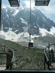
The Chamonix Aiguilles dominate the view from the valley with the spectacular cablecar whisking you airily up to the summit of the Aiguille du Midi. The half-way station on the cablecar is Plan de l'Aiguille and this is the starting point for this route. This means the walk can easily be combined with a visit to the summit.
From Plan d'Aiguille the route takes you northeast along the 'Grand Balcon Nord' or the northern balcony path. Undulating around the 2000 metres above sea level mark, this path is a popular route due to the ease of access and the superb views.
The route is signed from the cablecar station and takes you beneath the soaring peaks of the Chamonix Aiguilles to the upper station of the Montenvers electric railway. The start of the route, although signed, is confusing although a look along the mountainside will soon reveal where the path is heading.
In early summer the route is a veritable rock garden with flowers and flowering shrubs providing a dash of colour. Once on the path the route is straightforward as it meanders along the mountainside. Across the valley there are good views of the Aiguilles Rouges with Chamonix in the valley below. Eventually you will reach a junction of paths near to Montenvers. The choice is straight ahead for the direct path to Montenvers station or a right turn for the preferred route over Signal Forbes. Assuming the latter option is taken the path climbs some 150 metres in a series of tight zigzags that make ascent a dream.
At the top of the path you reach a col and your efforts are rewarded with a superb view of the Aiguille Verte (4122 m). You might be tempted to head down into Montenvers but a little more effort will take you to the viewpoint of Signal Forbes from where you can gaze down over the Mer de Glace (Sea of Ice) far below. For the more adventurous you can climb further along the ridge perhaps gaining some solitude to enjoy the spectacular mountain views.
Things to consider - This can be a busy walk in good weather during the high season. The views are better lit in the afternoon and if you are a keen photographer then this is the time to walk the route. Ensure you leave enough time to catch the last train down to Chamonix from Montenvers. It is a tedious walk if you were intending to take the train! Early and late season may see snow across the path. This walk is perfect for combining with a visit to the summit of the Aiguille du Midi. This is a very busy cablecar in fine weather and an early start might be the best option if you want to miss the crowds.
Suggested Maps
 - Carte de Randonnées "Sheet A1 - Pays due Mont-Blanc" published by Rando Editions. 1:50000 scale - Sheet A1
- Map of Mountain Footpaths in Summer - 1:40000 - Published by the Office de Tourisme
- IGN Carte de Randonnée - Chamonix - Massif de Mont Blanc - 1:25000 Sheet 3630OT
Stay Safe
Do enjoy yourself when out walking and choose a route that is within your capabilities especially with regard to navigation.
Do turn back if the weather deteriorates especially in winter or when visibility is poor.
Do wear the right clothing for the anticipated weather conditions. If the weather is likely to change for the worse make sure you have enough extra clothing in your pack.
Do tell someone where you are planning to walk especially in areas that see few other walkers.
Do take maps and other navigational aids. Do not rely on mobile devices in areas where reception is poor. Take spare batteries especially in cold weather.
Do check the weather forecast before leaving. The Met Office has a number of forecasts for walkers that identify specific weather risks.
Please Note - These walks have been published for use by site visitors on the understanding that Walking Britain is not held responsible for the safety or well being of those following the routes as described. It is worth reiterating the point that you should embark on a walk with the correct maps preferably at 1:25000 scale. This will enable any difficulties with route finding to be assessed and corrective action taken if necessary.