Pré de Madame Carle - Glacier Noir, Ecrins
Walk 6013
Country - France
Region - Haute Alpes (05) - Vallee de la Vallouise - Ecrins NP
Author - Lou Johnson
Length - 8.0 km / 5 miles
Ascent - 630 metres / 2079 feet
Descent - 630 metres / 2079 feet
Time - 4.00 hours
Grade - moderate
Click image to visit gallery of 3 images.
This straighforward walk starts from the wide flat galcial plain of Pré de Madame Carle and after crossing the river follows the northern moraine of the Glacier Noir into a superb mountain cirque at just above the 2500 metre contour. As with any walk along a glacial moraine care is needed as crumbling edges are common and with the retreat of glaciers due to global warming it can be a long way down to the ice!
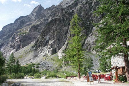
The route is an out and back walk that starts from the large cap park at Pré de Madama Carle. A National Park Centre, toilets and a refuge serving a wide range of food and refreshments can all be found around the trail head. Follow the wide path north to cross the river. This vantage point provides an excellent view upstream to the Glacier Noir and you get a preview of the wild scenery that is encountered on this walk.
Continue along the wide path and begin the acsend. Reaching a path junction turn left and follow a distinct but somewhat narrower path that ascends at a relatively gentle angle onto the moraine. As mentioned before, moraines do crumble and there are places where there is evidence if recent subsidence. Continue steadily upwards penetrating mountain scenery that is wild and uncompromising to reach a large stone cairn. This is where most walkers turn around.
However further progress into the rocky cirque can be accomplished following the path, which in places can be considered as rather fragile and liable to crumble at any minute. Eventually at just over 2500 metres further progress becomes unwise. There are few places in Europe where walkers can enjoy so wild a prospect. You should therefore allow time to absorb the rugged character of this location before returning to the start.
Suggested Maps
 - IGN Carte de Randonnée - Meije Pelvoux - Parc National des Ecrins - 1:25000 Sheet 3436ET
Stay Safe
Do enjoy yourself when out walking and choose a route that is within your capabilities especially with regard to navigation.
Do turn back if the weather deteriorates especially in winter or when visibility is poor.
Do wear the right clothing for the anticipated weather conditions. If the weather is likely to change for the worse make sure you have enough extra clothing in your pack.
Do tell someone where you are planning to walk especially in areas that see few other walkers.
Do take maps and other navigational aids. Do not rely on mobile devices in areas where reception is poor. Take spare batteries especially in cold weather.
Do check the weather forecast before leaving. The Met Office has a number of forecasts for walkers that identify specific weather risks.
Please Note - These walks have been published for use by site visitors on the understanding that Walking Britain is not held responsible for the safety or well being of those following the routes as described. It is worth reiterating the point that you should embark on a walk with the correct maps preferably at 1:25000 scale. This will enable any difficulties with route finding to be assessed and corrective action taken if necessary.