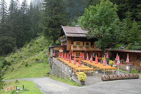
Stilluptal from the Grüne Wald Hütte
Walk 6033
Country - Austria
Region - Zillertal (Tyrol)
Author - Lou Johnson
Length - 8.0 km / 5 miles
Descent - 320 metres / 1056 feet
Time - 2.00 hours
Grade - easy/mod
Click image to visit gallery of 12 images.
This walk through the Stillup Valley (Stilluptal) uses the private road in the upper reaches of the valley and continues downstream to Gasthaus Wasserfall.
Start - Grüne Wald Hütte.
End - Gasthaus Wasserfall
The Gasthaus Wasserfall can be reached by road from Mayrhofen. There is a private bus service that operates from Mayrhofen main car park (behind the Post Office). Note the bus does not serve the main bust station adjacent to the railway station. There are a number of services each day and information is available from the Tourist Office. From the Gasthaus Wasserfall there is an 'on demand' minibus service up the valley private road to the Grüne Wald Hütte and this must be used by everyone including those with private cars.
From the Grüne Wald Hütte (warm welcome, refreshments and food) you already have an excellent view down the valley. The route is simple, just follow the road back to the Gasthaus Wasserfall. The Stilluptal offers a look at summer farming in Austria with farms scattered along the valley road. It is a pleasant pastoral scene. Roughly half way is the Stilluphaus, which offers food and refreshments. Nearing the end of the walk there are two tunnels. One is avoided by a path around the lake shore whilst the other has to be walked through with care.
Suggested Maps
 - Mayrhofen Tuxer Tal - Wanderkarte - 1:25000 - www.wave.at
Stay Safe
Do enjoy yourself when out walking and choose a route that is within your capabilities especially with regard to navigation.
Do turn back if the weather deteriorates especially in winter or when visibility is poor.
Do wear the right clothing for the anticipated weather conditions. If the weather is likely to change for the worse make sure you have enough extra clothing in your pack.
Do tell someone where you are planning to walk especially in areas that see few other walkers.
Do take maps and other navigational aids. Do not rely on mobile devices in areas where reception is poor. Take spare batteries especially in cold weather.
Do check the weather forecast before leaving. The Met Office has a number of forecasts for walkers that identify specific weather risks.
Please Note - These walks have been published for use by site visitors on the understanding that Walking Britain is not held responsible for the safety or well being of those following the routes as described. It is worth reiterating the point that you should embark on a walk with the correct maps preferably at 1:25000 scale. This will enable any difficulties with route finding to be assessed and corrective action taken if necessary.