Lac de Gaube from Pont d'Espagne, near Cauterets
Walk 6051
Country - France
Region - Haute Pyrenees (65)
Author - Lou Johnson
Length - 4.0 km / 2.5 miles
Ascent - 150 metres / 495 feet
Descent - 275 metres / 908 feet
Grade - easy
Click image to visit gallery of 3 images.
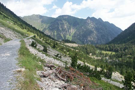
This valley walk explores a small area with views of the French Pyrenees to the south of Cauterets. This town is a good regional centre and still retains its spa, which was once a very fashionable attraction in the 19th century.
To reach the start of this walk, follow the D920 south through la Raillère to the large car park at the end of the road for public access just short of Pont d'Espagne. After parking, walk along the road (ignoring the temptation of using the Télécabine du Pountas) to reach the historic Pont d'Espagne. Do not go left but continue ahead to the valley station of the télésiège de Gaube. This takes you easily up into the mountains. Leave the top station and take the signed path to Lac de Gaube. The scenery is immediately grand and dramatic.
The view ahead is excellent and you will soon see the small hôtellerie on the left-hand side of Lac de Gaube. This is the first objective and a source of refreshments and ice creams in season. After having enjoyed the view and perhaps strolled along the lakeside path, return to the main path junction at the northern end of the lake.
You can of course return the way you came but for a small extra effort the down hill walk to the Pont d'Espagne is very pleasant and saves a few euros expenditure. From the path junction bear left for the télésiège or right to walk back to the start. The way ahead is easy follow and the descent easy in very pleasant surroundings.
Suggested Maps
 - IGN Carte de Randonnée - Vignemalle - Ossau, Arrens, Cauterets - 1:25000 Sheet 1647OT
Stay Safe
Do enjoy yourself when out walking and choose a route that is within your capabilities especially with regard to navigation.
Do turn back if the weather deteriorates especially in winter or when visibility is poor.
Do wear the right clothing for the anticipated weather conditions. If the weather is likely to change for the worse make sure you have enough extra clothing in your pack.
Do tell someone where you are planning to walk especially in areas that see few other walkers.
Do take maps and other navigational aids. Do not rely on mobile devices in areas where reception is poor. Take spare batteries especially in cold weather.
Do check the weather forecast before leaving. The Met Office has a number of forecasts for walkers that identify specific weather risks.
Please Note - These walks have been published for use by site visitors on the understanding that Walking Britain is not held responsible for the safety or well being of those following the routes as described. It is worth reiterating the point that you should embark on a walk with the correct maps preferably at 1:25000 scale. This will enable any difficulties with route finding to be assessed and corrective action taken if necessary.