Pointe du Grouin to Cancale
Walk 6096
Country - France
Region - Ille et Vilaine (35) - Brittany
Author - Lou Johnson
Time - 2.50 hours
Grade - easy/mod
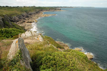
Click image to visit gallery of 12 images.
The walk follows a section of the long distance footpath GR34 or Sentier des Douaniers along the beautiful Brittany coastline and offers views across the sea to le Mont-St-Michel as well as a visit to the "oyster town" of Cancale. The coastal path is well marked and surprisingly has many ups and downs. Refreshments are available at Point du Grouin, Port Mer and then nothing until Cancale is reached.
A useful benefit for visitors (presumably only in season) is the free mini-bus service that links Cancale with Pointe du Grouin. Operating every 30 minutes this 'navette' follows a circular route that includes the Port at Cancale, the main centre of Cancale and the Pointe du Grouin. There are two options. Firstly park at Cancale and catch the Navette to the Pointe. Parking in Cancale can be problematic as it is a busy place in season. The second alternative is to park at the Pointe, walk to Cancale and catch the Navette back to the start. Parking is probably easier at the Pointe although no check was made on the size of the car park or the costs.
The walk starts by the bus stop at Pointe. There is a café close by. Take the clear wide footpath north towards the point. It is a rugged spot with wonderful views along the coast west and south and across the bay to le Mont-St-Michel. After taking in the view follow the clearly marked path along the cliff tops south towards Cancale. The path is marked with the usual red and white flashes although some are in rather obscure positions.
The path clings to the cliff tops before descending to Port Mer. Follow the road along the beach past a number of small restaurants and cafés. At the southern end of the beach you follow the road around to the right to locate GR34 on your left.
The path follows the cliff tops with some nice views back to Port Mer before snaking round the Pointe du Chatry and a decent into Port Pican where there are no refreshments and public toilets. The onward path needs care to locate and climbs onto the cliff tops once more before descending again to Port Briac (again no refreshments).
A further climb onto the cliff tops leads to Pointe de la Chaine from where you have a view across to the two small islands just offshore. Rounding the Pointe de la Chaine the route urns southwest towards the Pointe du Hock from where you get a superb view over the oyster beds and the port of Cancale. All that remains is to descend to the port.
Walking time was approximately 2 hrs 30 minutes taken at a leisurely pace. When planning the walk do take into account the lack of refreshments as the section from Port Mer to Cancale takes just under two hours.
Suggested Maps
 - IGN Carte de Randonnée - St-Malo, Dinard, Dinan - 1:25000 Sheet 1116 ET
Stay Safe
Do enjoy yourself when out walking and choose a route that is within your capabilities especially with regard to navigation.
Do turn back if the weather deteriorates especially in winter or when visibility is poor.
Do wear the right clothing for the anticipated weather conditions. If the weather is likely to change for the worse make sure you have enough extra clothing in your pack.
Do tell someone where you are planning to walk especially in areas that see few other walkers.
Do take maps and other navigational aids. Do not rely on mobile devices in areas where reception is poor. Take spare batteries especially in cold weather.
Do check the weather forecast before leaving. The Met Office has a number of forecasts for walkers that identify specific weather risks.
Please Note - These walks have been published for use by site visitors on the understanding that Walking Britain is not held responsible for the safety or well being of those following the routes as described. It is worth reiterating the point that you should embark on a walk with the correct maps preferably at 1:25000 scale. This will enable any difficulties with route finding to be assessed and corrective action taken if necessary.