Courmayeur - Mont De La Saxe - Val Ferret
Walk 6103
Country - Italy
Region - Aosta Valley
Author - Alpine Interface
Ascent - 1330 metres / 4389 feet
Grade - mod/hard
Click image to visit gallery of 2 images.
If based in Chamonix, one would have to take the Mont Blanc Tunnel and park in the town of Courmayeur (1250 metres).
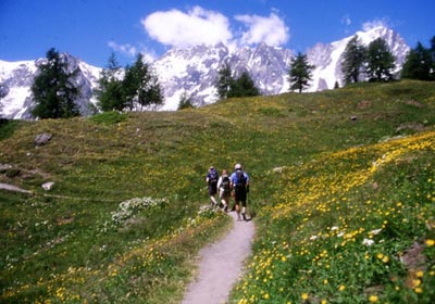
The walk begins next to the Guide's Office (Guida Alpina) which is in the centre of town near the main church. One heads north towards the hamlet of Villair following the yellow diamonds that indicate the walking path. From Villair, one heads out of the village and the signs that indicate the Mont de la Saxe and the Rifugio Bertone. The trail winds its way at first along a forester's track and then into a larch forest where one has to cross a small bridge.
It takes about 2 hours of gentle ascent to reach the Rifugio Bertone (1991 metres). This family-run refuge provides excellent meals, wine and coffee. One can also spend the night but it is wise to reserve ahead of time.
The views just above the Bertone hut are some of the best in the Alps. The southern flanks of the Mont Blanc jut upwards and the famous Aiguille Noire de Peutrey and the Brenva Spur are just across the Val Ferret. Some of the best and hardest climbing routes in the Alps are located on the southern side of Mont Blanc.
The remainder of climb to the Saxe ridge is steep but very short, lasting only about 30 minutes. From there, the views to the north-west are spectacular and the walking very gentle. There are several possibilities to shorten the walk but it is best to carry on to Tête de Bernade (2534 metres) and then to Tête de la Tronche (2584 metres) where views are stunning. Keep to the obvious main path since there are many smaller trails that end up nowhere.
One must descend steeply to the Col du Sapin (2436 metres) where there are signs indicating a return route to the Val Ferret. One takes the path past the ruins of the Tsa de Secheron and follows the stream heading towards Armina at 2009 metres. From there, one can see the Val Ferret and the road. It takes about 1.5 hours back to the valley floor and one can return to Courmayeur using the very good shuttle bus service that runs nearly every 15 minutes at various stops along the valley floor.
Walking Times :
Courmayeur to Rifugio Bertone 2 hours
Bertone to the Col Sapin 2 hours
Col Sapin to Val Ferret and Bus 1.5 hours
Suggested Maps
 - Carte Nationale Suisse 1:50,000 Courmayeur
Stay Safe
Do enjoy yourself when out walking and choose a route that is within your capabilities especially with regard to navigation.
Do turn back if the weather deteriorates especially in winter or when visibility is poor.
Do wear the right clothing for the anticipated weather conditions. If the weather is likely to change for the worse make sure you have enough extra clothing in your pack.
Do tell someone where you are planning to walk especially in areas that see few other walkers.
Do take maps and other navigational aids. Do not rely on mobile devices in areas where reception is poor. Take spare batteries especially in cold weather.
Do check the weather forecast before leaving. The Met Office has a number of forecasts for walkers that identify specific weather risks.
Please Note - These walks have been published for use by site visitors on the understanding that Walking Britain is not held responsible for the safety or well being of those following the routes as described. It is worth reiterating the point that you should embark on a walk with the correct maps preferably at 1:25000 scale. This will enable any difficulties with route finding to be assessed and corrective action taken if necessary.