Pico Ruivo and return from Pico do Arieiro
Walk 6123
Country - Portugal
Region - Madeira
Author - Peter Schofield
Grade - moderate
Click image to visit gallery of 5 images.
This walk is probably the best known high level route on Madeira and consequently one of the most popular. That said, it offers stunning views and a variety of flora and fauna and well deserves its popularity. The whole route is well waymarked and in good condition and route finding is no problem.
Two notes of caution at the outset. Even though the path is securely fenced, like many walks on Madeira the drop offs are substantial and anyone without a head for heights should not attempt it. Secondly, don't be deceived by the minimal height difference between the start point (1818m) and Pico Ruivo (1862m). The complete walk includes six ascents totalling around 1000m in all.
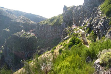
The route starts at the far end of the car park at Pico do Arieiro. Follow the paved path from the information board as it descends for almost 1K to level out briefly at a narrow saddle and the first of the many drop offs. To the left the valley falls steeply away to Curral das Freiras and the south coast, while to the right the Ribeira da Medade valley goes to the north coast. At this point, the narrow path truly forms the island's watershed.
A gentle climb follows to reach a path junction near the viewpoint at Nino da Manta. Go left following the path as it contours around a small summit before reaching a steep stepped descent to another saddle. Ahead lies Pico do Gato but fortunately we don't have to climb it as a short tunnel takes the path under it. About 500m after the tunnel, a path junction is reached. The left hand path offers a shorter and easier route to Pico Ruivo but at the time of writing (Feb 2008) access to it was barred.
Continue instead along the right hand path as it climbs gently through alpine vegetation before reaching the steepest ascent of the walk around Pico das Torres where a series of seemingly endless steps climb 300m in a little under 1K. At last, relief comes as the top is reached and as you round the corner, Pico Ruivo comes into view for the first time.
Another descent follows as views open out on the right into the valley of the Ribeira Seca while ahead the path can be seen snaking its way on a narrow ledge below the cliff face. A waymarker is reached at a tunnel where the closed alternative route rejoins and the path starts to gently climb through some of the oldest woodland on the island. After steadily climbing for a further 1.3K, you arrive at a path junction where a waymarker announces the good news that the summit of Pico Ruivo is just 0.5K away!
Continue straight up the path for a short distance to a mountain hut and go left to ascend towards the summit, arriving at a junction after 300m. The path to the right is another outstanding walk to Boca da Encumeada but that's for another day. Instead our route goes left and climbs the last few metres to arrive at the viewing platform on the peak of Pico Ruivo. In clear weather, there are expansive views to both the north and south coasts and also to the east of the island. Even on a cloudy day, Pico Ruivo often basks in sunshine above the clouds.
When you've had your fill of the view, return by the same route. The final climb up to the car park at Pico do Arieiro can seem interminable at the end of a day’s walking, but you will have enjoyed a memorable trip.
The start is not served by scheduled public transport but a number of companies in Funchal offer private transport arrangements. Details can be obtained from the TIC in Funchal.
Suggested Maps
 - 1:40000 maps showing footpaths are widely available throughout Madeira
Stay Safe
Do enjoy yourself when out walking and choose a route that is within your capabilities especially with regard to navigation.
Do turn back if the weather deteriorates especially in winter or when visibility is poor.
Do wear the right clothing for the anticipated weather conditions. If the weather is likely to change for the worse make sure you have enough extra clothing in your pack.
Do tell someone where you are planning to walk especially in areas that see few other walkers.
Do take maps and other navigational aids. Do not rely on mobile devices in areas where reception is poor. Take spare batteries especially in cold weather.
Do check the weather forecast before leaving. The Met Office has a number of forecasts for walkers that identify specific weather risks.
Please Note - These walks have been published for use by site visitors on the understanding that Walking Britain is not held responsible for the safety or well being of those following the routes as described. It is worth reiterating the point that you should embark on a walk with the correct maps preferably at 1:25000 scale. This will enable any difficulties with route finding to be assessed and corrective action taken if necessary.