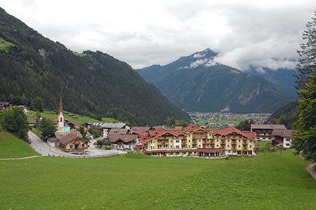
Finkenberg to Mayrhofen
Walk 6024
Country - Austria
Region - Zillertal (Tyrol)
Author - Lou Johnson
Length - 4.0 km / 2.5 miles
Descent - 206 metres / 680 feet
Time - 1.25 hours
Grade - easy
Click image to visit gallery of 6 images.
This easy walk offers some fine views of the Ziller Valley (Zillertal) together with a section alongside the dramatic gorge where the River Tuxbach has carved a route through rock.
Start - the valley station of the Finkenberger Almbahn
End - railway & bus station in Mayrhofen
To start the walk locate the footpath at the back of the cable car station. This can be accessed by walking pass the restaurant on its western side. Turn right along the footpath 31 descending towards Mayrhofen. Cross the road bridge providing access to the Cemetery. This offers fine views down to the river and through the deep gorge.
Reaching the south bank of the river, turn left and follow path 32 towards Mayrhofen. The path passes through delightful woodland. After a short way you reach a viewpoint, which offers an excellent vantage point from which to study the gorge. The path continues to descend using zigzags to lose height. Reaching a road, continue to descend by following the road downhill. You reach a small chapel by a wooden bridge over the Zemmbach River. The chapel is worth further inspection as is the bridge.
Do not cross the bridge, instead turn left and follow the signed footpath to Mayrhofen. You soon rejoin path 31. Turn right onto this and continue along the river bank to reach a main road. Cross over with care and follow the signed footpath. The path soon crosses the river. Continue by keeping the river on your left. The path diverts to the main road for a short distance and crosses the Ziller River. Immediately after this bridge, turn left and stay with the riverside footpath to the railway and bus station.
Suggested Maps
 - Mayrhofen Tuxer Tal - Wanderkarte - 1:25000 - www.wave.at
Stay Safe
Do enjoy yourself when out walking and choose a route that is within your capabilities especially with regard to navigation.
Do turn back if the weather deteriorates especially in winter or when visibility is poor.
Do wear the right clothing for the anticipated weather conditions. If the weather is likely to change for the worse make sure you have enough extra clothing in your pack.
Do tell someone where you are planning to walk especially in areas that see few other walkers.
Do take maps and other navigational aids. Do not rely on mobile devices in areas where reception is poor. Take spare batteries especially in cold weather.
Do check the weather forecast before leaving. The Met Office has a number of forecasts for walkers that identify specific weather risks.
Please Note - These walks have been published for use by site visitors on the understanding that Walking Britain is not held responsible for the safety or well being of those following the routes as described. It is worth reiterating the point that you should embark on a walk with the correct maps preferably at 1:25000 scale. This will enable any difficulties with route finding to be assessed and corrective action taken if necessary.