Panorama walk from Col des Tentes, near Gavarnie
Walk 6047
Country - France
Region - Haute Pyrenees (65)
Author - Lou Johnson
Length - 8.0 km / 5 miles
Ascent - 200 metres / 660 feet
Descent - 200 metres / 660 feet
Grade - easy/mod
Click image to visit gallery of 6 images.
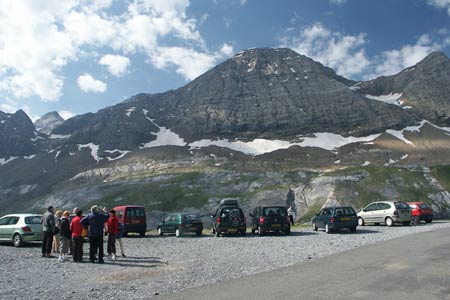
This walk offers some grand views over the village of Gavarnie and the surrounding mountains. It also offers a glimpse into neighbouring Spain. The start is the car park at the Col du Tentes reached by a winding road that zigzags dramatically out of Gavarnie. When approaching Gavarnie on the D921 from Gedre, turn right at the first major junction in the village and follow this road ever upwards.
Continue along the road to reach the car park at Col du Tentes. After parking continue along the road, which has barricades to stop traffic to reach the French/Spanish border at Port du Boucharo. From here you have a wonderful view into Spain and you will note the coloured strata of rock on some of the mountains.
Turn sharp left and follow the path uphill onto the northern flank of Le Taillon. The path traverses the side of this mountain gaining height very gradually. Early in the season you will encounter patches of snow when care is required. The route is easy to follow and you get the feeling of being high in the mountains without having used up too much effort. Continue on this path until it turns south and begins to climb more steeply over rock. This is the point to return to the start.
The path does continue to the Refuge des Sarradets and the Brèche de Roland. However there are a couple of sections where the use of hands is necessary and after a cold night the rock can be icy near streams. It is prior to these difficulties that this walk turns back but if you wish to continue then follow walk 6112.
Suggested Maps
 - IGN Carte de Randonnée - Gavarnie - Luz-St-Saveur - 1:25000 Sheet 1748OT
Stay Safe
Do enjoy yourself when out walking and choose a route that is within your capabilities especially with regard to navigation.
Do turn back if the weather deteriorates especially in winter or when visibility is poor.
Do wear the right clothing for the anticipated weather conditions. If the weather is likely to change for the worse make sure you have enough extra clothing in your pack.
Do tell someone where you are planning to walk especially in areas that see few other walkers.
Do take maps and other navigational aids. Do not rely on mobile devices in areas where reception is poor. Take spare batteries especially in cold weather.
Do check the weather forecast before leaving. The Met Office has a number of forecasts for walkers that identify specific weather risks.
Please Note - These walks have been published for use by site visitors on the understanding that Walking Britain is not held responsible for the safety or well being of those following the routes as described. It is worth reiterating the point that you should embark on a walk with the correct maps preferably at 1:25000 scale. This will enable any difficulties with route finding to be assessed and corrective action taken if necessary.