The Chillar River (Rio Chillar) from Nerja
Walk 6115
Country - Spain
Region - Malaga Province (Andalucia)
Author - Peter Bailey
Length - 5.0 km / 3.1 miles
Grade - moderate
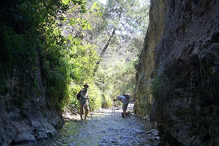
Click image to visit gallery of 4 images.
Walking is not possible from the end of May to the beginning of September in southern Spain. This walk is one of the few exceptions: it is best in June, July and August, because you walk along a cool river bed in a narrow, shady canyon. Unlike many Andalusian rivers, this one has water, at least from the "fabrica de luz" (a very small hydroelectric station).
Obviously you have absolutely no chance of ending the walk with dry feet. Wear old trainers and shorts. A walking stick is very useful, as the river bed is stony. In places the canyon is so narrow that you can touch both sides at the same time. The flora and fauna are not at all typical of southern Spain. You will see a variety of ferns and other shade-loving plants and beautiful butterflies and dragon flies.
The walk is easy but the stones in the river might make it a bit more difficult for some people, especially children. In places you can swim in shallow pools, so take a towel.
How to get there: Nerja is accessible from Malaga by bus. You can get to the river via calle Julio Romero de Torres, then turn left into calle Solana and finally go right in to Picasso, one of the streets above the Municipal Sports Centre, leading to a broad track which descends to the river bed. You can also get to the river from El Playazo Beach. If you take the latter route (which is longer) keep on the right hand side of the river (when facing the mountains).
The WalkFollowing the unsurfaced track which follows the banks of the river Chíllar, you will arrive at the confluence with the river Higuerón (which forks off to the left). Continuing on the right hand side of river, you eventually reach a small cement works and from this point the river bed narrows. You go this far by car (and perhaps a little further) but you must park the car before you reach the little hydroelectric station.
If the water in the river has dried up, do not worry, there will be water above the hydroelectric station. From here you have to continue on foot. The first few yards (3 or 4) are steep and sometimes slippery as you navigate a ramp up to the real start of the walk. The walk gets better and better from here on. No description is needed: you could not possibly get lost from this point onwards. How far you go is up to you. You can continue for a few miles but the going is slow.
Warning - there are always dangers when water is present and supervision of all children is essential. It also wise not to use this route in periods when heavy rainstorms are likley.
Stay Safe
Do enjoy yourself when out walking and choose a route that is within your capabilities especially with regard to navigation.
Do turn back if the weather deteriorates especially in winter or when visibility is poor.
Do wear the right clothing for the anticipated weather conditions. If the weather is likely to change for the worse make sure you have enough extra clothing in your pack.
Do tell someone where you are planning to walk especially in areas that see few other walkers.
Do take maps and other navigational aids. Do not rely on mobile devices in areas where reception is poor. Take spare batteries especially in cold weather.
Do check the weather forecast before leaving. The Met Office has a number of forecasts for walkers that identify specific weather risks.
Please Note - These walks have been published for use by site visitors on the understanding that Walking Britain is not held responsible for the safety or well being of those following the routes as described. It is worth reiterating the point that you should embark on a walk with the correct maps preferably at 1:25000 scale. This will enable any difficulties with route finding to be assessed and corrective action taken if necessary.