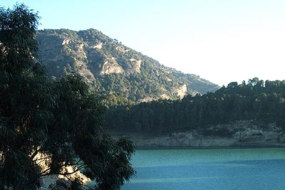
Point 604 from Pantano del Chorro
Walk 6002
Country - Spain
Region - Malaga Province (Andalucia)
Author - Lou Johnson
Length - 7.0 km / 4.4 miles
Ascent - 320 metres / 1056 feet
Descent - 320 metres / 1056 feet
Time - 2.50 hours
Grade - easy/mod
Click image to visit gallery of 6 images.
This walk starts from the dam at Pantano del Chorro where on road parking is available. The dam can be reached by following the minor road from Ardales located on the Malaga to Campillos main road. The route is ill defined in places and it must be remembered that there are some steep crags in places.
From the dam walk back along the road to Ardales. There is usually very little traffic and there are good views to your right across the reservoir. Reaching the entrances to Camping Parque Ardales on your right, ignore the first access road and continue on the road to the second access. Almost opposite is a path into the woodland. There are red and white waymarks although these are erratic and badly positioned.
The path climbs up to a small col. Turn left here to follow a feint path that climbs onto the southern slopes of 'Point 604'. The route needs care as there are crags to your left but generally the route even though not continuously waymarked is logical and straightforward. As you climb the views over the reservoirs improve. By the time you have reached the summit of 'Point 604' you will be rewarded with a grand view of La Huma (1188 m) and be able to see the route of the El Chorro gorge.
The descent goes north at first veering northwest. A few waymarks exist and generally it is a matter of heading downhill avoiding the worst of the bushes and small crags at the same time following an obvious path where it is apparent. You will exit onto a dirt road. Turn left along this dirt road and this will lead you back to the road used on the onward route. Turn right and you will soon be back at the dam.
Things to consider - Do not stray from the route described. There are numerous crags in this area and with the El Chorro gorge never far away danger could be only a step away. In summer this area can be very hot and despite numerous small trees there is very little usable shade.
Suggested Maps
 - Cartografia Militar de Espana, Series L, 1:50000, Sheet no. 16-43 (1043), Ardales.
Stay Safe
Do enjoy yourself when out walking and choose a route that is within your capabilities especially with regard to navigation.
Do turn back if the weather deteriorates especially in winter or when visibility is poor.
Do wear the right clothing for the anticipated weather conditions. If the weather is likely to change for the worse make sure you have enough extra clothing in your pack.
Do tell someone where you are planning to walk especially in areas that see few other walkers.
Do take maps and other navigational aids. Do not rely on mobile devices in areas where reception is poor. Take spare batteries especially in cold weather.
Do check the weather forecast before leaving. The Met Office has a number of forecasts for walkers that identify specific weather risks.
Please Note - These walks have been published for use by site visitors on the understanding that Walking Britain is not held responsible for the safety or well being of those following the routes as described. It is worth reiterating the point that you should embark on a walk with the correct maps preferably at 1:25000 scale. This will enable any difficulties with route finding to be assessed and corrective action taken if necessary.