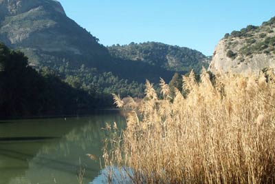
Desfiladero de los Gaitanes from Pantano del Chorro
Walk 6004
Country - Spain
Region - Malaga Province (Andalucia)
Author - Lou Johnson
Length - 6.5 km / 4.1 miles
Ascent - 150 metres / 495 feet
Descent - 150 metres / 495 feet
Time - 2.00 hours
Grade - easy/mod
Click image to visit gallery of 2 images.
This walk starts from the dam at Pantano del Chorro where on road parking is available. The dam can be reached by following the minor road from Ardales located on the Malaga to Campillos main road. The route is easy to follow and should present no difficulties. However it is not recommended to continue down the gorge using the remains of the concrete walkway that is now in ruins.
From the dam walk back along the road to Ardales. The road sees very little traffic and to your right there are good views to the reservoir. Just before the road enters a tunnel, look out for a small pedestrian tunnel on your left. It is quite dark and the headroom is limited in places but it quickly leads you under a ridge and into the valley in which the Desfiladero de Los Gaitanes is located.
Shortly after leaving the tunnel the path joins a track and this is followed downhill with a further reservoir to your left. Reaching some buildings that form part of the hydroelectric scheme follow the path on the western side of the river that leads to the start of the derelict walkway through the gorge. You may also descend to the dam and cross to the other side. From here you can see further into the northern end of this spectacular gorge.
The return route follows outward route. Take care not to miss the footpath through the tunnel. Should you fail to locate this then stay on the track, keeping left at the junction, and will exit onto the road at the southern end of the road tunnel.
Things to consider - Do not stray from the route described. You should under no circumstances try to use the abandoned walkway. In places the concrete floor has deteriorated to such an extent that stepping on it may cause it to crumble. Do not forget to take adequate drinks for the walk.
Suggested Maps
 - Cartografia Militar de Espana, Series L, 1:50000, Sheet no. 16-43 (1043), Ardales.
Stay Safe
Do enjoy yourself when out walking and choose a route that is within your capabilities especially with regard to navigation.
Do turn back if the weather deteriorates especially in winter or when visibility is poor.
Do wear the right clothing for the anticipated weather conditions. If the weather is likely to change for the worse make sure you have enough extra clothing in your pack.
Do tell someone where you are planning to walk especially in areas that see few other walkers.
Do take maps and other navigational aids. Do not rely on mobile devices in areas where reception is poor. Take spare batteries especially in cold weather.
Do check the weather forecast before leaving. The Met Office has a number of forecasts for walkers that identify specific weather risks.
Please Note - These walks have been published for use by site visitors on the understanding that Walking Britain is not held responsible for the safety or well being of those following the routes as described. It is worth reiterating the point that you should embark on a walk with the correct maps preferably at 1:25000 scale. This will enable any difficulties with route finding to be assessed and corrective action taken if necessary.