Planpraz to Chalet de la Flégère
Walk 6007
Country - France
Region - Haute Savoie (74) - Chamonix Valley
Author - Lou Johnson
Length - 5.0 km / 3.1 miles
Ascent - 90 metres / 297 feet
Descent - 210 metres / 693 feet
Time - 1.75 hours
Grade - easy/mod
Click image to visit gallery of 6 images.
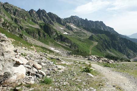
This is a scenic walk along part of the 'Grand Balcon Sud' high level path offering excellent views across the Arve Valley to Mont Blanc and many other well-known Alpine peaks. The path is also a section of the 'Tour du Mont Blanc' long-distance route.
Take the Télécabine from Chamonix to Planpraz. Exit the cablecar station and walk northwest along a track keeping the ski-lift on your right. After a short way you reach a junction of paths. Take the right fork to contour across the mountainside. Keep right at the next junction and continue enjoying fine views across the Arve Valley to Mont Blanc and many other peaks.Nearing a rocky spur the path joins a wide track which is soon abandoned for a much nicer path to reach a path junction at La Charlanon.
At this junction go straight across. The path climbs through trees to exit onto an excellent section of the route that has a true Alpine character with the path crossing steep mountainside with views across the valley to the Aiguille Verte particularly fine. Arrival at Chalet de la Flégère is without further problem.
Things to consider - This walk deserves good weather as the views are superb. By using the L'Index télésiege from Chalet de la Flégère you can extend the walk to Lac Blanc (see Walk 6003).
Suggested Maps
 - Carte de Randonnées "Sheet A1 - Pays due Mont-Blanc" published by Rando Editions. 1:50000 scale - Sheet A1
- Map of Mountain Footpaths in Summer - 1:40000 - Published by the Office de Tourisme
- IGN Carte de Randonnée - Chamonix - Massif de Mont Blanc - 1:25000 Sheet 3630OT
Stay Safe
Do enjoy yourself when out walking and choose a route that is within your capabilities especially with regard to navigation.
Do turn back if the weather deteriorates especially in winter or when visibility is poor.
Do wear the right clothing for the anticipated weather conditions. If the weather is likely to change for the worse make sure you have enough extra clothing in your pack.
Do tell someone where you are planning to walk especially in areas that see few other walkers.
Do take maps and other navigational aids. Do not rely on mobile devices in areas where reception is poor. Take spare batteries especially in cold weather.
Do check the weather forecast before leaving. The Met Office has a number of forecasts for walkers that identify specific weather risks.
Please Note - These walks have been published for use by site visitors on the understanding that Walking Britain is not held responsible for the safety or well being of those following the routes as described. It is worth reiterating the point that you should embark on a walk with the correct maps preferably at 1:25000 scale. This will enable any difficulties with route finding to be assessed and corrective action taken if necessary.