Refuge de Bel Lachat to Chamonix
Walk 6011
Country - France
Region - Haute Savoie (74) - Chamonix Valley
Author - Lou Johnson
Length - 9.0 km / 5.6 miles
Ascent - 110 metres / 363 feet
Descent - 1000 metres / 3300 feet
Time - 3.50 hours
Grade - moderate
Click image to visit gallery of 6 images.
Starting from the Refuge de Bel Lachat, which offers an excellent place to relax and enjoy the scenery with excellent food, this route descends into the Chamonix Valley using the route of the Tour Mont Blanc (TMB). The path is well graded and progress down into the valley is fast. This route makes an ideal extension to walk 6010.
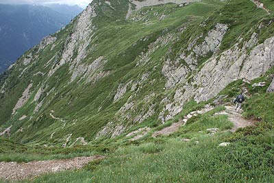
From the Refuge walk west to the reach the junction with the TMB. Turn left and immediately start to descend. The path loses height quickly using a succession of well graded zigzags. Of note are three stream crossings in the first section down to the valley path. In spate these would be impassable or very difficult to cross. Under normal conditions they present no problems. The descent offers wonderful views across the Chamonix Valley with the great fingers of glaciers dropping into valley down the opposite mountain particularly impressive.
Reaching the valley path near the 'Parc Animalier' at Merlet, turn left. Do not follow the TMB, which goes right. Shortly after joining the main valley path you have to cross the first of a number of streams. Again in spate all of these would be difficult or impossible to cross. The first one was crossed higher in the descent and cannot be avoided. However the others can be avoided by descending to les Montquarts and following the path along the Arve River back to Chamonix. Joining the 'Petit Balcon' path after the junction for les Montquarts, the route is pleasant passing through woods where wild raspberries can be found in season!
There are a number of points where careful navigation is required although generally it is safe to take the lower path where there is an option. However at Vallot take the right fork and descend towards the outskirts of Chamonix. The path feeds into a road and walking through the suburbs you reach the valley station of the Planpraz Télécabine. Here turn right downhill into the centre of Chamonix.
Suggested Maps
 - Carte de Randonnées "Sheet A1 - Pays due Mont-Blanc" published by Rando Editions. 1:50000 scale - Sheet A1
- Map of Mountain Footpaths in Summer - 1:40000 - Published by the Office de Tourisme
- IGN Carte de Randonnée - Samoëns - Haut Giffre - 1:25000 Sheet 3530ET
Stay Safe
Do enjoy yourself when out walking and choose a route that is within your capabilities especially with regard to navigation.
Do turn back if the weather deteriorates especially in winter or when visibility is poor.
Do wear the right clothing for the anticipated weather conditions. If the weather is likely to change for the worse make sure you have enough extra clothing in your pack.
Do tell someone where you are planning to walk especially in areas that see few other walkers.
Do take maps and other navigational aids. Do not rely on mobile devices in areas where reception is poor. Take spare batteries especially in cold weather.
Do check the weather forecast before leaving. The Met Office has a number of forecasts for walkers that identify specific weather risks.
Please Note - These walks have been published for use by site visitors on the understanding that Walking Britain is not held responsible for the safety or well being of those following the routes as described. It is worth reiterating the point that you should embark on a walk with the correct maps preferably at 1:25000 scale. This will enable any difficulties with route finding to be assessed and corrective action taken if necessary.