Ailefroide - Bosse de Clapouse, Ecrins
Walk 6012
Country - France
Region - Haute Alpes (05) - Vallee de la Vallouise - Ecrins NP
Author - Lou Johnson
Length - 8.0 km / 5 miles
Ascent - 675 metres / 2228 feet
Descent - 675 metres / 2228 feet
Time - 4.00 hours
Grade - moderate
Click image to visit gallery of 6 images.
This walk provides visitors to the mountain village of Ailefroide in the Ecrins National Park with a good excuse to put on their boots and go for a walk. Ailefroide is one of those places that is full of people enjoying the outdoors whether they be be climbers, mountaineers or walkers.
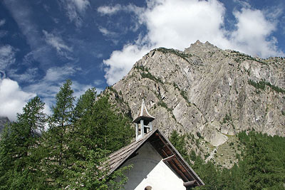
For the purposes of this description I have started the directions from the small chapel on the main street of the village. From here walk north along the road to a junction. Turn left. This will lead you past the edge of the large camping area on your left to reach a car park (an alternative start if you have transport).
Go through the car park and follow the clear path signed to the "Refuge Sele, Refuge Pelvoux and Clapouse". The going is fairly level with the path following the river upstream to reach a path junction in just over 15 minutes. Turn left here and descend to cross the river on a footbridge.
Once safely across the torrent continue on the path as it gains height in loops and zigzags, offering ever improving views of the surrounding mountains. Generally the gradient is never too steep and you make suprisingly rapid progress up the side of a valley passing a waterfall as you near the top.
Eventually the gradient eases and you arrive in a hanging valley with many small footpaths going left. Take one of these and keep climbing to reach a small hill with a few pine trees. This is the Bosse de Clapouse. It is a perfect venue for a picnic with a grand panorama to the north.
To return retrace the outward route.
Suggested Maps
 - IGN Carte de Randonnée - Meije Pelvoux - Parc National des Ecrins - 1:25000 Sheet 3436ET
Stay Safe
Do enjoy yourself when out walking and choose a route that is within your capabilities especially with regard to navigation.
Do turn back if the weather deteriorates especially in winter or when visibility is poor.
Do wear the right clothing for the anticipated weather conditions. If the weather is likely to change for the worse make sure you have enough extra clothing in your pack.
Do tell someone where you are planning to walk especially in areas that see few other walkers.
Do take maps and other navigational aids. Do not rely on mobile devices in areas where reception is poor. Take spare batteries especially in cold weather.
Do check the weather forecast before leaving. The Met Office has a number of forecasts for walkers that identify specific weather risks.
Please Note - These walks have been published for use by site visitors on the understanding that Walking Britain is not held responsible for the safety or well being of those following the routes as described. It is worth reiterating the point that you should embark on a walk with the correct maps preferably at 1:25000 scale. This will enable any difficulties with route finding to be assessed and corrective action taken if necessary.