Pré de Madame Carle - Refuge du Glacier Blanc, Ecrins
Walk 6014
Country - France
Region - Haute Alpes (05) - Vallee de la Vallouise - Ecrins NP
Author - Lou Johnson
Length - 8.0 km / 5 miles
Ascent - 675 metres / 2228 feet
Descent - 675 metres / 2228 feet
Time - 4.50 hours
Grade - mod/hard
Click image to visit gallery of 9 images.
The walk to the Refuge du Glacier Blanc involves a climb out of the valley in a series of well-graded zigzags to reach a hidden valley into which Glacier Blanc drains. The path is clear and well signed apart from a short but confusing section identified in the text.
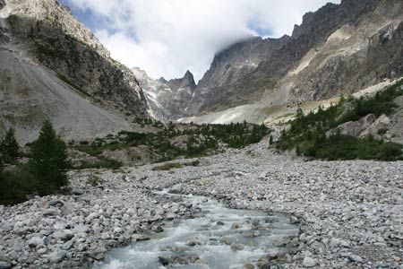
From the large carpark at Pré de Madame Carle take the wide path that goes to the right of the restaurant/refuge Cezanne. This leads across the valley floor to cross a fast moving stream by a substantial bridge. If there are other walkers on the path you can see the route ahead climbing the valley side. Reaching a path junction go right and begin the first of many zigzags cleverly designed to keep the grade walkable.
There are a few Marmotte burrows near the path and some are very friendly and will beg for food. However there are signs advising you not to feed them as it disturbs their diet. Continuing the climb, you lose count of the zigzags. Generally speaking the path is easy with just occasional scetions requiring the use of hands.
Eventually the path reaches a small crest before descending into an glacial amphitheatre that contains many discarded boulders. The path crosses the glacial stream by means of a bridge before climbing the rocks ahead. To your left is the Glacier Blanc.
After crossing the bridge there are a couple of routes that lead nowhere and you need to retreat. The red markers are a help and if there are other walkers about watch them and follow those who seem to have chosen the best route. The problems are short-lived and soon you are on a well mraked path that requires a little more hard work than before as you gain height more rapidly.
Reaching a flatter area with some small tarns you get a good view of the glacier with the Refuge du Glacier Blanc high on a rocky bluff to the right of the glacier. The final climb is reached with some cables on the tricky bits to bring you to the Refuge. A good variety of food and drink is available with a superb view to enjoy. To return just follow the outward route taking care on the descent to the bridge over the glacier outflow.
Suggested Maps
 - IGN Carte de Randonnée - Meije Pelvoux - Parc National des Ecrins - 1:25000 Sheet 3436ET
Stay Safe
Do enjoy yourself when out walking and choose a route that is within your capabilities especially with regard to navigation.
Do turn back if the weather deteriorates especially in winter or when visibility is poor.
Do wear the right clothing for the anticipated weather conditions. If the weather is likely to change for the worse make sure you have enough extra clothing in your pack.
Do tell someone where you are planning to walk especially in areas that see few other walkers.
Do take maps and other navigational aids. Do not rely on mobile devices in areas where reception is poor. Take spare batteries especially in cold weather.
Do check the weather forecast before leaving. The Met Office has a number of forecasts for walkers that identify specific weather risks.
Please Note - These walks have been published for use by site visitors on the understanding that Walking Britain is not held responsible for the safety or well being of those following the routes as described. It is worth reiterating the point that you should embark on a walk with the correct maps preferably at 1:25000 scale. This will enable any difficulties with route finding to be assessed and corrective action taken if necessary.