The Karspitze (2264m) from Zell-am-Ziller
Walk 6026
Country - Austria
Region - Zillertal (Tyrol)
Author - Lou Johnson
Ascent - 480 metres / 1584 feet
Descent - 480 metres / 1584 feet
Time - 5.00 hours
Grade - moderate
Click image to visit gallery of 3 images.
This walk takes you to the summit of the Karspitze, which offers fine views in all directions. Although parts of the walk are affected by ski infrastructure, the route does provide an excellent walk in this area.
Start & End - Zillertalbahn Railway Station in Zell-am-Ziller. Alternatively start from the valley station of the Kreuzjochbahn.
Exit the railway station onto Bahnhofstrasse and turn right into the centre of Zell-am-Ziller. At the main road junction turn right. Cross the railway and turn left passing the brewery. Stay on this road out of torn until you reach the valley station of the Kreuzjochbahn. Take this two stage gondola cablecar to the top station (1744m).
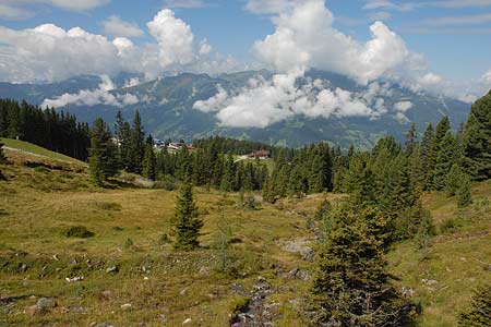
Exit the cablecar station and bear left on path 10. Follow the signs to the 'old' Kreuzjochhütte (30 minutes). The route is along a broad track that winds uphill offering some good views into the Zillertal. From the Kreuzjochhütte (food & refreshments) continue on the track climbing more steeply towards the 'new' Kreuzjochhütte (closed in summer). The route is signed Kreuzjoch and Karspitze. This area has suffered from too much ski infrastructure although the wonderful views remain.
Climbing higher you pass the junction where the path to the Kreuzjoch bears left. After a short way and some more uphill work the track levels and you can see the summit of the Karspitze marked with a cross on your left. Red and white paint flashes mark the trail to the summit (2264m). The view east and south east is excellent with little visual pollution from ski lifts.
Descend on the path signed to the Kreuzweisenalm Hütte (path 11). The path descends over rock at first and is well marked with red and white markers. The route then continues to descend over grass and is well marked throughout. The path ends when you reach a wide track. The direct way back is to turn right here. However if you turn left the Kreuzweisenalm Hütte (food & refreshments) is reached in a few minutes.
After visiting the Hütte retrace your steps and continue along the main track back towards the top station of the Kreuzjochbahn. After approximately 20/30 minutes look out for a footpath sign on your left to 'Rosenalm'. This leads through woodland and across meadows back to the cablecar station.
Stay Safe
Do enjoy yourself when out walking and choose a route that is within your capabilities especially with regard to navigation.
Do turn back if the weather deteriorates especially in winter or when visibility is poor.
Do wear the right clothing for the anticipated weather conditions. If the weather is likely to change for the worse make sure you have enough extra clothing in your pack.
Do tell someone where you are planning to walk especially in areas that see few other walkers.
Do take maps and other navigational aids. Do not rely on mobile devices in areas where reception is poor. Take spare batteries especially in cold weather.
Do check the weather forecast before leaving. The Met Office has a number of forecasts for walkers that identify specific weather risks.
Please Note - These walks have been published for use by site visitors on the understanding that Walking Britain is not held responsible for the safety or well being of those following the routes as described. It is worth reiterating the point that you should embark on a walk with the correct maps preferably at 1:25000 scale. This will enable any difficulties with route finding to be assessed and corrective action taken if necessary.