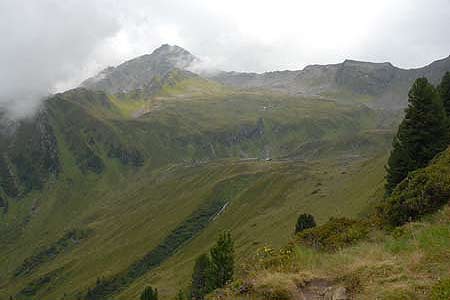
Ahornspitz (2973m) from the Ahornbahn
Walk 6028
Country - Austria
Region - Zillertal (Tyrol)
Author - Lou Johnson
Length - 10.0 km / 6.3 miles
Ascent - 1030 metres / 3399 feet
Descent - 1030 metres / 3399 feet
Time - 5.50 hours
Grade - mod/hard
Click image to visit gallery image.
This walk ascends the Ahornspitz (2973m) after having gained some mechanical assistance from the Ahornbahn. The route is well marked and provides a good day in the mountains with excellent views (in good weather) to the surrounding valleys and mountains.
Start & End - the top station of the Ahornbahn cable car.
Exit the top station of the Ahornbahn and bear left to following the broad path rising towards the Ahornhütte. This is likely to be quite busy as it also the route to the Edelhütte. Reaching a stone wall, turn right. This leads you down a short descent to an ornate gateway. Go through this gate and follow the clear path across the mountainside. The path from here to the Edelhütte is essentially uphill but there is some loss of altitude. The path is generally well maintained and is easy to follow in poor visibility. For strong walkers the Edelhütte can be reached in under an hour.
The Edelhütte is the focus point of five paths radiating in all directions. Just before reaching the hut there is a sign pointing the way to the Ahornspitze with the path rising almost due east. The path is in reasonable condition with height gained using zigzags and loops. As height is gained the path becomes more difficult under foot and there a few places where there is some limited exposure. The summit offers wide ranging views.
The easiest descent is to retrace your steps the way you came. However for those competent in mountain walking there is an alternative. Rather than take the route described above follow Path 519 south from the Edelhütte towards the Kasseler Hütte. Having gained the Popbergnieder (2451m), bear left off path 519 and start to ascend the southwest ridge of the Ahornspitze. This is not a maintained path and it is in poor condition in places. There is also some exposure in places. Care is required in poor visibility as the path is not well trodden and difficult to follow. Having gained the summit the easiest option is to descend via the route described above.
Suggested Maps
 - Mayrhofen Tuxer Tal - Wanderkarte - 1:25000 - www.wave.at
Stay Safe
Do enjoy yourself when out walking and choose a route that is within your capabilities especially with regard to navigation.
Do turn back if the weather deteriorates especially in winter or when visibility is poor.
Do wear the right clothing for the anticipated weather conditions. If the weather is likely to change for the worse make sure you have enough extra clothing in your pack.
Do tell someone where you are planning to walk especially in areas that see few other walkers.
Do take maps and other navigational aids. Do not rely on mobile devices in areas where reception is poor. Take spare batteries especially in cold weather.
Do check the weather forecast before leaving. The Met Office has a number of forecasts for walkers that identify specific weather risks.
Please Note - These walks have been published for use by site visitors on the understanding that Walking Britain is not held responsible for the safety or well being of those following the routes as described. It is worth reiterating the point that you should embark on a walk with the correct maps preferably at 1:25000 scale. This will enable any difficulties with route finding to be assessed and corrective action taken if necessary.