Ahornbahn Panorama Walk
Walk 6037
Country - Austria
Region - Zillertal (Tyrol)
Author - Lou Johnson
Length - 2.0 km / 1.3 miles
Ascent - 150 metres / 495 feet
Descent - 150 metres / 495 feet
Time - 1.00 hours
Grade - easy
Click image to visit gallery of 3 images.
This short walk offers a wide range of views of the valleys and mountains surrounding the regional centre of Mayrhofen. The walk is suitable for those with 'all terrain' pushchairs. There is a selection of cafés available.
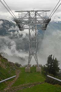
Start & End - the top station of the Ahornbahn cablecar.
Leave the Ahornbahn by the main exit and turn right. You will see a large information board by the toilets. This provides details of the immediate area, suggested walks and other information. Take the broad path to the right of the toilet block and descend in an arc to the Filzenalm. From this part of the walk there are good views over the Tuxer Valley and the Penken.
Continue on the broad path as it snakes its way uphill. On the right there are superb views down into the Stillup Valley (Stilluptal) with a specially constructed viewing area just off the path. Continue uphill staying on the main path to reach a path junction by an ornate gateway. Do not go through the gate but continue on the path following the wall, which should be on your right hand side. The views have now changed and you can see towards the Ahornspitze (2973m) and the Edelhütte.
Ignore the broad path going left and walk straight ahead to reach a spectacular newly constructed viewpoint offering an exceptional view the length of the Ziller Valley (Zillertal) with Mayrhofen some 1350 metres below (4500 feet). It is possible to continue a short way past the viewing area to a higher point. However do be careful as there is a considerable drop off the unprotected crags. After enjoying the view walk back down the path to the first junction and turn right. This leads back to the top station of the Ahornbahn.
Suggested Maps
 - Mayrhofen Tuxer Tal - Wanderkarte - 1:25000 - www.wave.at
Stay Safe
Do enjoy yourself when out walking and choose a route that is within your capabilities especially with regard to navigation.
Do turn back if the weather deteriorates especially in winter or when visibility is poor.
Do wear the right clothing for the anticipated weather conditions. If the weather is likely to change for the worse make sure you have enough extra clothing in your pack.
Do tell someone where you are planning to walk especially in areas that see few other walkers.
Do take maps and other navigational aids. Do not rely on mobile devices in areas where reception is poor. Take spare batteries especially in cold weather.
Do check the weather forecast before leaving. The Met Office has a number of forecasts for walkers that identify specific weather risks.
Please Note - These walks have been published for use by site visitors on the understanding that Walking Britain is not held responsible for the safety or well being of those following the routes as described. It is worth reiterating the point that you should embark on a walk with the correct maps preferably at 1:25000 scale. This will enable any difficulties with route finding to be assessed and corrective action taken if necessary.