La Grave, les Hières & Hameau de Valfroide
Walk 6041
Country - France
Region - Haute Alpes (05) - La Grave & La Meije - Ecrins NP
Author - Lou Johnson
Length - 12.0 km / 7.5 miles
Ascent - 610 metres / 2013 feet
Descent - 610 metres / 2013 feet
Time - 5.00 hours
Grade - moderate
Click image to visit gallery of 12 images.
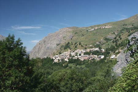
This lengthy walk explores the Romanche Valley between Villar d'Arène and La Grave before climbing into a side valley to Hameau de Valfroide. The latter sections of the route offer grandstands views of La Grave and the surrounding scenery.
Start & End - The village of Villar d'Arène located just off the N91 a few kilometres east of La Grave.
From the village square take the signed path by the side of the Auberge Aux Trois Frênes down to the bridge across the River Romanche. Cross the bridge and go right following the river downstream towards La Grave. You are now on GR54. The route ahead is easy to follow and after a short ascent you drop down to the river bridge by the Camping de la Meije. Cross the bridge and walk up the access road into La Grave.
Walk uphill in the La Grave village past the Church on your left. Making for the highest part of the village, go left in front of Le Château and then right onto a path signed to Ventelon. This path climbs steeply to reach a road at a hairpin bend. Take the short cut across the bend and join the road walking uphill towards Ventelon. At the road junction turn right to les Hières.
At les Hières stay on the upper road through the village. The road deteriorates into a track and continues into the valley with the le Maurian Torrent below on your right. Continue up the valley passing a number of small hamlets to reach Le Pré Rond. Shortly after this point, cross the bridge on your right over le Maurian Torrent. The path descends a little to reach a junction. Bear left here and start to climb. The middle section of the route is the steepest but the effort is well rewarded with excellent views.
Reaching a the grassy Col de l'Aiguillon (2059m), take the short ascent to the summit of l'Aiguillon (2095m) from where there is a wonderful view of the Romanche Valley. Return to the col and turn right along a path/track, which makes for excellent walking as you contour across the hillside. Reaching a parking area and access road, there is the option of making the short diversion to the Lac du Pontet. To do this, turn left and continue up hill.
To continue, descend down the road towards the hamlet of les Cours. Just before the first building, turn right down the path signed to Villar d'Arène. This path takes you past a small chapel to the main N91 road. Cross road and return to the village centre.
Suggested Maps
 - IGN Carte de Randonnée - Valloire - Aiguilles d'Arves, Col du Galibier - 1:25000 Sheet 3435ET
Stay Safe
Do enjoy yourself when out walking and choose a route that is within your capabilities especially with regard to navigation.
Do turn back if the weather deteriorates especially in winter or when visibility is poor.
Do wear the right clothing for the anticipated weather conditions. If the weather is likely to change for the worse make sure you have enough extra clothing in your pack.
Do tell someone where you are planning to walk especially in areas that see few other walkers.
Do take maps and other navigational aids. Do not rely on mobile devices in areas where reception is poor. Take spare batteries especially in cold weather.
Do check the weather forecast before leaving. The Met Office has a number of forecasts for walkers that identify specific weather risks.
Please Note - These walks have been published for use by site visitors on the understanding that Walking Britain is not held responsible for the safety or well being of those following the routes as described. It is worth reiterating the point that you should embark on a walk with the correct maps preferably at 1:25000 scale. This will enable any difficulties with route finding to be assessed and corrective action taken if necessary.