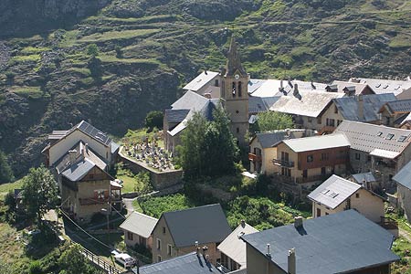
Le Chazelet and the Oratoire du Chazelet.
Walk 6043
Country - France
Region - Haute Alpes (05) - La Grave & La Meije - Ecrins NP
Author - Lou Johnson
Length - 4.0 km / 2.5 miles
Ascent - 100 metres / 330 feet
Descent - 100 metres / 330 feet
Time - 2.00 hours
Grade - easy
Click image to visit gallery of 9 images.
An easy walk that explores the village of le Chazelet above La Grave. The walk offers some wonderful views of La Meije and should be completed late afternoon to benefit from the best light.
Start & End - The car park near the Pont du Pertus on the north western side of the le Chazelet. This is reached by following the D33 by pass above the village to its end.
From the car park, walk back down the lane towards le Chazelet. Bear right down into the village at the first fork in the road. The village has many interesting buildings, a nice church with an interesting graveyard plus excellent views of the surrounding area. After exploring the village continue along the lane to regain the D33 and follow this to the Oratoire du Chazelet.
This shrine is located at the summit of the road with fine views across the Romanche Valley to La Meije. By taking the path on the left opposite the shrine you climb up to a better viewpoint with an orientation table. This provides detailed information on the superb panorama. For most people La Meije is the main attraction although the view into the valley over 500 metres below is spectacular with villages dotted across the landscape.
To complete the walk return along the D33 towards le Chazelet taking the bypass above the village back to the car park.
Suggested Maps
 - IGN Carte de Randonnée - Valloire - Aiguilles d'Arves, Col du Galibier - 1:25000 Sheet 3435ET
Stay Safe
Do enjoy yourself when out walking and choose a route that is within your capabilities especially with regard to navigation.
Do turn back if the weather deteriorates especially in winter or when visibility is poor.
Do wear the right clothing for the anticipated weather conditions. If the weather is likely to change for the worse make sure you have enough extra clothing in your pack.
Do tell someone where you are planning to walk especially in areas that see few other walkers.
Do take maps and other navigational aids. Do not rely on mobile devices in areas where reception is poor. Take spare batteries especially in cold weather.
Do check the weather forecast before leaving. The Met Office has a number of forecasts for walkers that identify specific weather risks.
Please Note - These walks have been published for use by site visitors on the understanding that Walking Britain is not held responsible for the safety or well being of those following the routes as described. It is worth reiterating the point that you should embark on a walk with the correct maps preferably at 1:25000 scale. This will enable any difficulties with route finding to be assessed and corrective action taken if necessary.